Monthly Archives: February 2020

BREAKING NEWS: 2-3 Feet of Lake Effect Snow Today!

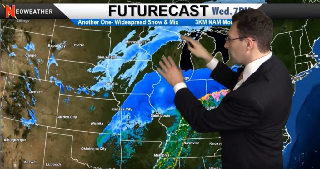
It’s not super rare to measure lake effect snow in the Upstate New York snow belt in feet, but this event is a real dandy! A long duration golden setup of lift, moisture and instability with very favorable wind direction. is across parts of the Great Lakes.

2/28/20 Lake Effect Snow Map - Two Feet of Snow Coming Today!
2/28/20 Lake Effect Snow Map – Two Feet of Snow Coming Today!

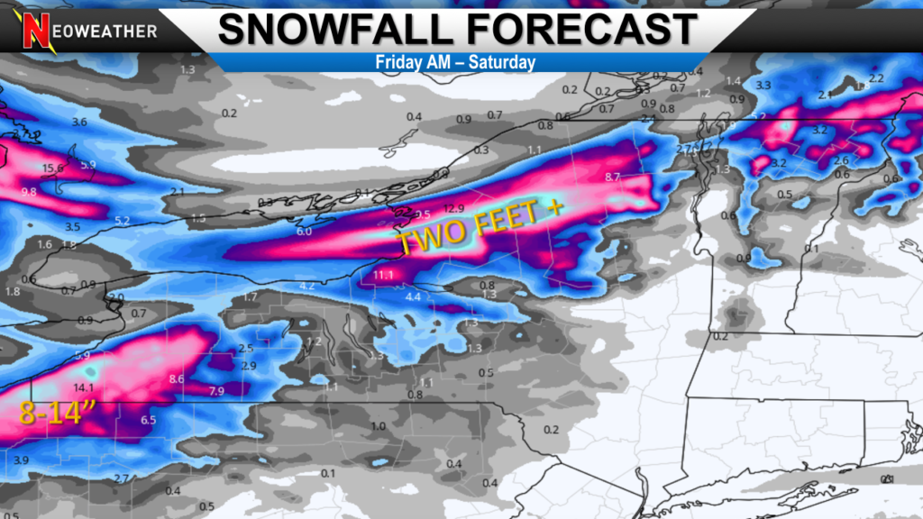
The key to a couple days of a great lake effect setup? Just look at the map. Lot’s of moisture around a strong low pressure system is wrapping around the Great Lakes. Follow the arrows. They take us across Superior, Michigan, Huron, and over Lake Ontario resulting in a “firehose band” of heavy snow. That’s a lot of moisture being funneled into the high terrain around Watertown, Carthage, and Sabbattis New York. The band even extends into Burlington, Vermont and eastward.

There is a pretty good chance a widespread 2-3 FEET occurs in the Tug Hills to the east of Lake Ontario.

The same setup will mean major snow of at least a foot of additional snow for the southeast side of Lake Erie. South of Buffalo gets hit very hard.

These type of events normally need a few important ingredients to line up and that’s what we have. A very strong low pressure is sitting and spinning over SE Canada. A high is over western Ontario. This synoptic setup allows for moisture, winds and cold air to be in place.

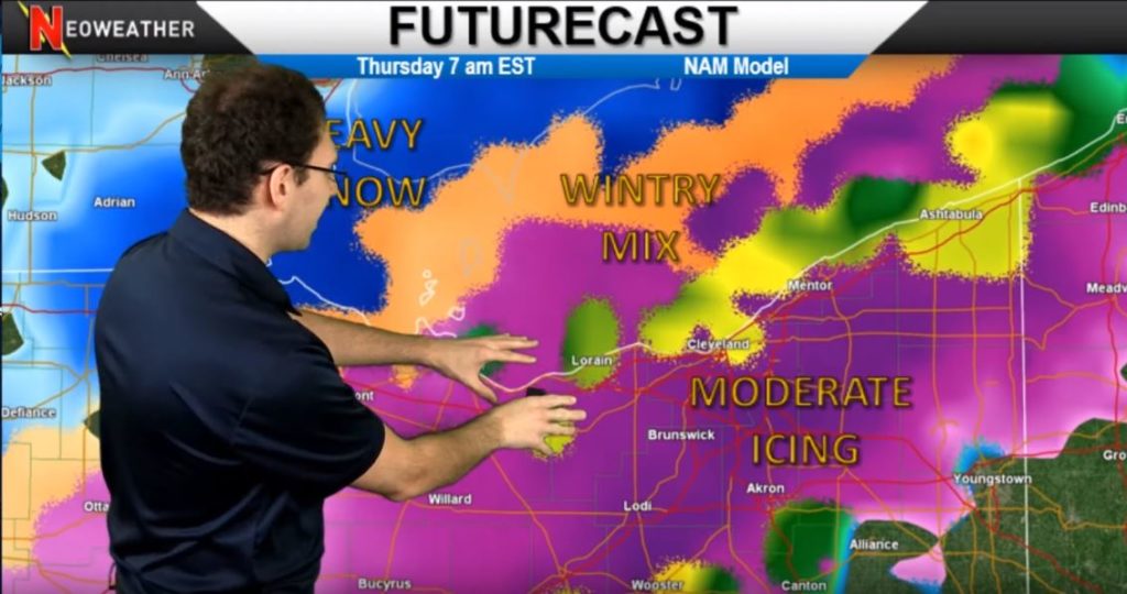
There will be several inches of snow possible in Northeast Ohio from this event also. The wind direction does not have the same length of the lake to work with as it does in New York, but that won’t stop the highest terrain from getting at least a half foot.

If you service those areas – happy plowing!

Snow is still coming this season in the Rockies & Midwest

This week’s big snow forecast shifted dramatically at the last minute, but there was still plenty of snow – just further south than expected earlier. What’s next? Some lake effect snow hits the Upper Midwest and the Northeast on Thursday and Friday. Then more activity kicks up on the Rockies on Sunday and early next week. After that warmer temperatures will setup a rainy pattern for the eastern half of the country.

2/25/20 Weather Forecast from Neoweather

All the hype about the huge winter storm set to dump on the Upper Midwest on Tuesday and Wednesday changed quite a bit late in the game. There was still significant snow for some areas, but it hit much further south than expected and some areas received little to no snow instead. This snow storm will circulate from Illinois, Indiana, Northwest Ohio, with Southwest Michigan getting the bulk of it. Then it moves on into Southern Ontario and Quebec, Canada. As it moves northeast and hits much colder air, the snow will really get heavy. That cold air really causes the storm to sit and spin too, making for a pretty decent snow event. It wraps up in New England with a fair amount of snow. The southern edges of this system will see a fair amount of rain instead of snow and even thunderstorms.

Midwest Snowstorm Map from Neoweather

Lake effect now will roll in after the action and Thursday and might hang on for a few days off and on. This is due to lots of moisture in the low pressure system still circulating around as the week wraps up.

A new system is expected to develop across the west starting on Sunday. That will bring smaller pockets of some snow in colder areas and rain in other regions as it moves east across the country early next week. It won’t be as cold next week so those systems are expected to be mostly rain.

Follow Neoweather Weather Consulting for expert storm updates and long range forecasts. They specialize in weather forecasting just for the snow and ice management industry. Contact Neoweather for more details!

How Will February Weather End? Look and See!

What does February 2020 have in store for us yet this year? Looks like warmer temps for most of the country for the next couple of weeks, then we may end on a colder note. Is Spring starting early? Will more wintery fun be on the way? See Brian Ivey’s February long range forecast based on following the most accurate weather models.

February 2020 Winter Weather Long Range Forecast Update

Everyone is wondering – will we see Spring early? It’s been above average temps on the coasts and Midwest with only the Rocky Mountains and portions of Texas with average to below averages in temperatures so far this month. As we move through the month, we’re expected to see some shots of cold air in the north with the heart of the arctic blast residing in Canada. But warmer weather from the south moves in to shut off that cold air from moving much into the U.S.

2/17/20 Temperature Anomaly Map from Neoweather
2/17/20 Temperature Anomaly Map showing above average temps

The end of the month will have a few days of spring like weather even in the north as a warmer spell hits Canada as well. That’s expected to be pushed out by a colder pattern coming across from the Rockies that might end the month on a cold note. So will March come in like a lion? Looks like a strong possibility! We could see some snowfall by Feb 29 in much of the country if things build up like expected.

February 2020 Precipitation

While the next couple of weeks are expected to be drier than usual, watch for some moist air to move into most of the country with the exception of the Pacific Coast. Going into Spring, moisture will return to the Tennessee Valley, Ohio Valley, Great Lakes and across the norther portion of the country. That could create a lot of active weather patterns and storms going into Spring. The Southwest is expected to be drier than average.

Love these long range forecasts as much as we do? Check out more from Neoweather or subscribe to their services today!

Big Snow Followed By an Arctic Blast This Week!

It’s time to bundle up and rev up those snowplow trucks if you are in the Great Lakes area and Northeast this week. Wednesday is expected to bring about a half foot of snow to the I-80 corridor and a major arctic blast will follow the storm (but not last long). Check out all the details in Brian Ivey’s video and in the summary that follows.

2/11/20 Weather Forecast Video from Neoweather

This week kicks off with lots of flooding rains in the deep south before that system moves across the East Coast and off our radar. That gives us plenty of time to watch the next major system brew up in the Texas and Oklahoma panhandles on Wednesday – and this one will be a doozy! The system will build and build as it moves across the country to the northeast. It will start to shake things up big time in Kansas, and drop several inches of snow. The front will continue to move into Illinois and the Ohio Valley… then, Bam! Another system will move down from the north and slam into it, giving the system an arctic boost for even more impact. This will create a good stripe of snow across I-80 and to the north. Michigan will get dumped on again, and the system will move across upstate New York and into New England on Thursday. Wrap around cold air and moisture on the backside of this system will create more snow in the Great Lakes region as well.

2/11/20 Weather Map showing snow from Neoweather

You might be able to relax after this storm rolls through, but don’t plan on enjoying any warmth! Temperatures WELL below zero will cover the Upper Midwest after the storm on Friday and into Saturday. Widespread lows of -5 to -20 degrees are expected across much of Wisconsin, Minnesota and Northern Illinois. Michigan and Ohio will see single digits.

2/16/20 Pacific Northwest Snow Map from Neoweather
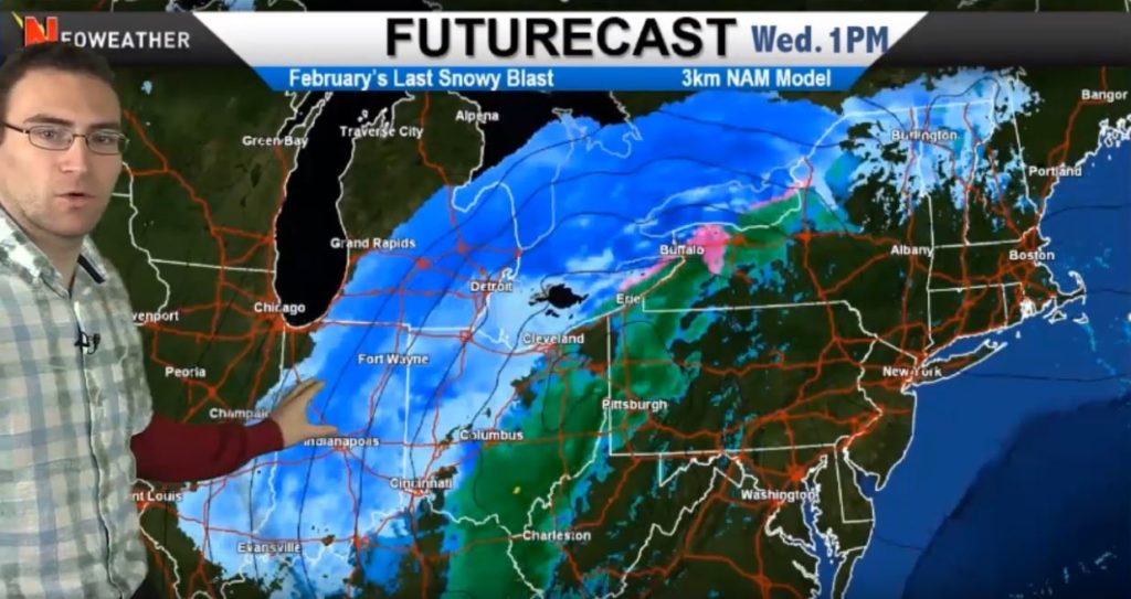
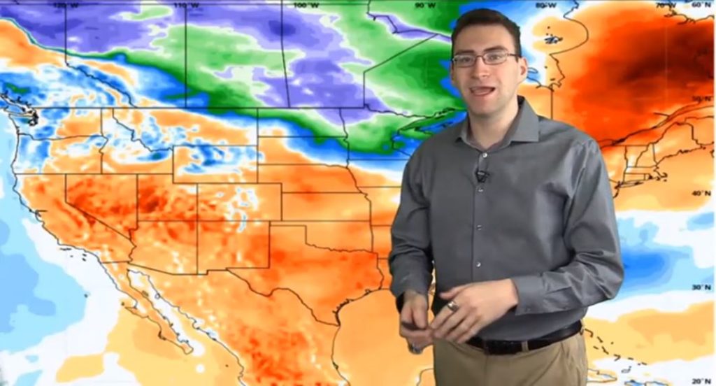
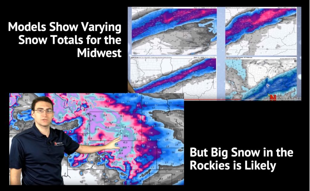
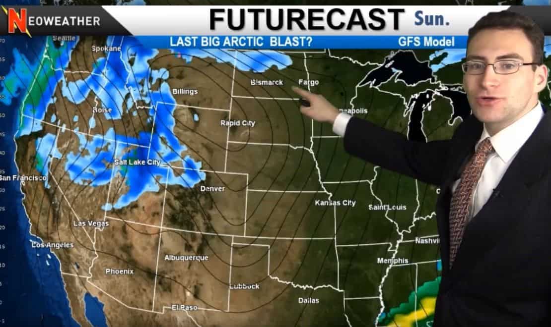
Saturday might bring a clipper down from Canada bringing more snow into Minnesota, Wisconsin and Michigan. However, the next big storm is laying its foundation over in the Pacific Northwest starting on Sunday. That storm is expected to track further north along the Canadian border and Northern Great Lakes region while the rest of the Midwest starts to warm up a bit. The rest of the country will have milder weather going into next week with some rain in parts of the East. After all this activity, average to above average temperatures are expected in most of the country next week. The middle of February overall is expected to be warmer than average will just a bit of cooler area in some areas.

Looking for a way to make better informed business decisions that depend on accurate weather forecasts? Neoweather can help! Contact them today for details!

SIMA: Resources You Don’t Want to Miss!

Everyone has heard of SIMA, and chances are that you are probably already a member if you operate snow and ice management services – but are you taking advantage of all the great resources they provide? Check out this video and post to make sure you are getting the most bang for your buck!

SIMA discusses resources available to members only

SIMA (Snow and Ice Management Association) brings incredible resources to its members and it’s a MUST HAVE membership program for all snow and ice management operations, manufacturers and suppliers. Why? Because they have an unbelievable arsenal of resources to support the snow business along with an investment in advocating for our industry. SIMA gives members access to training tools, exclusive news, operations tools (like template contracts and clauses), networking, and so much more. They also recently added services to help with recruiting, building, and retaining reliable employees. They also now have stronger business operations tools, marketing support and savings programs for members.

22nd Annual SIMA Snow & Ice Symposium

Martin Tirado from SIMA thinks the main benefits of joining the association include getting easy access to educational and training materials, sample contracts, sample production rates, and access to other contractors to expand your business network. Access to peer groups and a mentor program are also very valuable member benefits. SIMA’s online directory of snow contractors is very popular with members and customers seeking snow contractors too.

SIMA Best Practices Snow PlowingSIMA also focuses heavily on sharing best practices and standards for the snow and ice industry. For example, you can download a best practices checklist on salt management and storage. You can also get certified training and accreditation through SIMA membership. Operations managers and personnel can get ASM (Advanced Snow Manager) credentials by taking four individualized certificate courses online. SIMA also has the CSP (Certified Snow Professional) certification for snow and ice management company owners and executives. Documents and videos are available for download or instant viewing with membership to keep things nice and easy.

If you aren’t already a member of SIMA, what are you waiting for? It really is an absolute value that you should not be operating without. And if you are a member, are you up-to-date on all the latest resources they offer? Get more details on SIMA if you haven’t lately! You might be surprised at how much they can help your operations!

The Iceman Cometh… With Snow and a Wintery Mix too!

This week brings a wintery mix of rain, snow and ice depending on where you are located. The models on this vary a lot, but one thing is for sure – it won’t be a boring week!

2/4/20 Weather Forecast from Neoweather

This week kicks off with rain and warmer temperatures in the South that will be surging north and colliding with a cold front today. Early Wednesday brings the first taste of another wintery mix all the way down in Oklahoma and Texas. It moves northeast through Kansas and the Midwest up into Illinois and Indiana. It turns into snow by Thursday when it hits Michigan and continues to move northeast. As you can imagine, the northern half of this system will see snow (some heavy), the middle area will see a wintery mix and areas on the southern end of this system will start with rain and turn to ice once it hits cold surfaces. There will be some pretty decent amounts of precipitation through Thursday in the Northeast.

2/6/20 Weather System will have snow, a wintery mix and ice

This system will bring impressive amounts of snow over the Great Lakes and up into Ontario and Quebec. The southern end of this system will have heavy rain that is sometimes severe.

This weekend the Rockies will have an active snowy pattern while there is more rain in the south. The northern U.S. will see a clipper move through on Sunday and Monday that will bring some snow in just the northern states.

Expected Snowfall Totals Next Week

Models vary quite a bit for the Upper Midwest and Northeast snowfall totals. The exact impact will be determined by how things shift north and south. However, Neoweather states with confidence that the Rockies will see some serious accumulation again next week.

Week of 2/4/20 Weather Maps from Neoweather brought to you by Snow Plow News

Cold temps have been anchored in the across the West and will continue, but warmer than average temperatures will push into the deep south.

Looking for accurate and precise weather forecasts to help you make better decisions about your snow and ice management company? Check out Neoweather’s private forecasting service today!