Don’t let the calendar fool you – it may say November but Mother Nature is serving up a whopping taste of January weather for most of the country this week and next. The fun starts tomorrow for the Upper Midwest when snow stretches from Minneapolis down into Chicagoland. It will be wet and heavy as it moves east. But the real fun comes from the multiple blasts of cold air that pummel the north and northeastern half of the country starting Wednesday and continuing through next week – followed by the potential for some serious lake effect snow afterwards.
The first system that comes through the Upper Midwest on Wednesday will be light and fluffy snow on the northern side and wet and slushy snow/rain on the southern edges. The deep south will experience rain and moisture. But the real news is the cold! Cold blast #1 comes down from Canada on the heels of the snow Thursday. Then Saturday we get hit with round two of well below average temps that extend through the weekend. By Monday most of the eastern half of the United States is going to experience extreme cold. That’s right, a HUGE portion of the country will get a hearty dose of January-like temperatures next week!
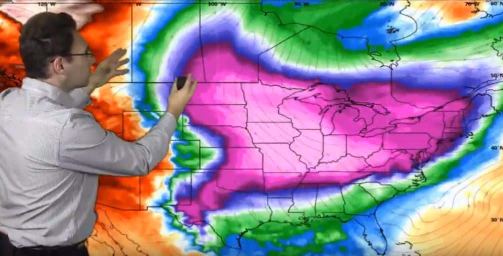
There will be a small break in the cold during the middle of next week, then it reloads again and we get hit with round three on the weekend of November 15th. Brace yourself for the coldest temperatures we’ve seen in 2019! You’ll have to go all the way down to the Tennessee Valley to find temps above freezing!
Now let’s look at the potential for snow. Models vary on this and much will depend on how the wind whips up. We could see some of these cold bursts turn into widespread snow makers starting on Saturday in the Upper Midwest, then Sunday and Monday across the Great Lakes and Ohio Valley and into the Northeast. By Monday through Wednesday of next week, we could be looking at a huge lake effect storm IF the winds line up with where the highs and lows are located. Multiple models show the potential for a significant snow event in the Upper Midwest and Great Lakes, as well as the New England area and Southern Canada. Regardless of the final numbers, this is going to be a snowy situation – not just extreme cold, so make sure you’re ready!
To make sure you are ALWAYS ready, consider a private weather forecasting service like Neoweather! They focus on helping snow contractors prepare for the specific weather hitting their exact service areas so you know what equipment, team members and products to have ready! Contact Neoweather for more information! Mention that you saw them on Snow Plow News to get 20% off your first month of service!