Monthly Archives: June 2020

The Heat is On! Will it be a Record Breaker?

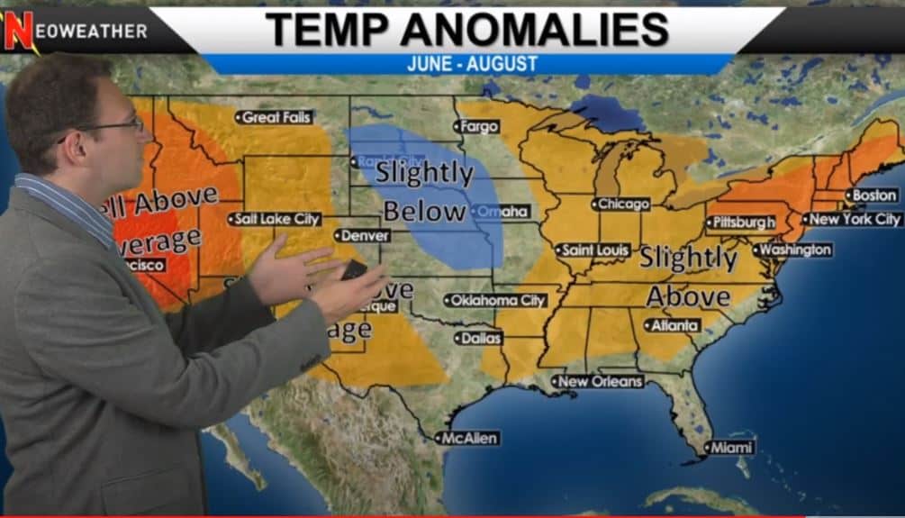
Among other things, July 2020 is bringing on the heat. Most of the country will above average temperatures with the only exception being the Pacific Northwest. Check out Brian Ivey’s forecast (and his new Hawaiian shirt) in this week’s weather video!

6/30/2020 Weather Forecast from Neoweather

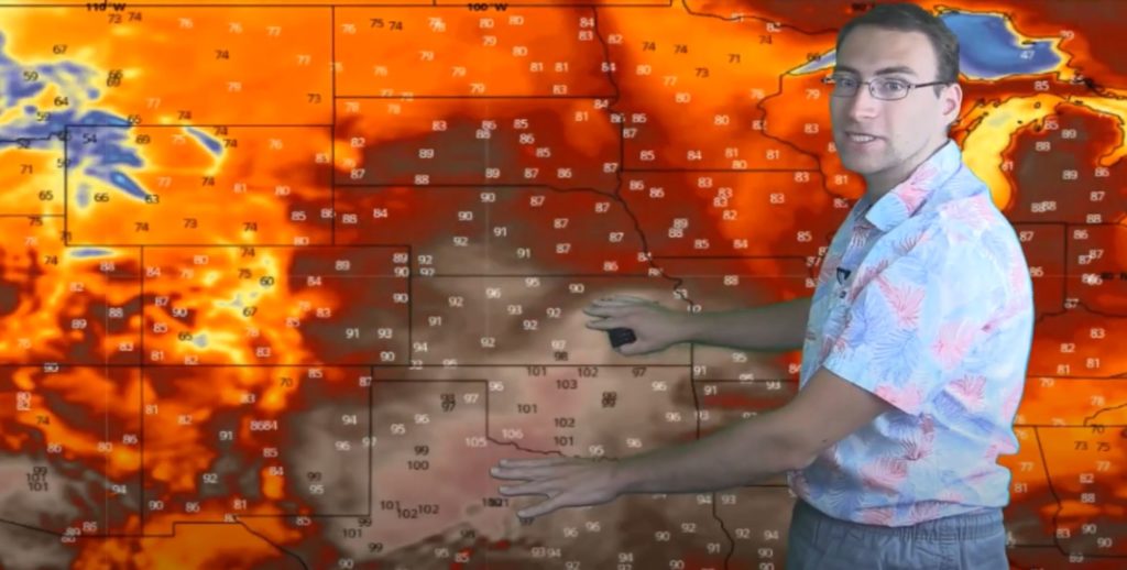
It’s a great week for most of the nation to head to the beach. The central and southern plains will have widespread triple-digit heat. The rest of the country will see widespread temps in the 80’s and 90’s. This heat wave is expected to stay consistent every day though the middle of next week.

This weather is a result of the high-pressure ridge that is pushing warm air up from the Gulf and keeping things hot and dry.

Week of 6/30/20 Heat Wave Weather Map

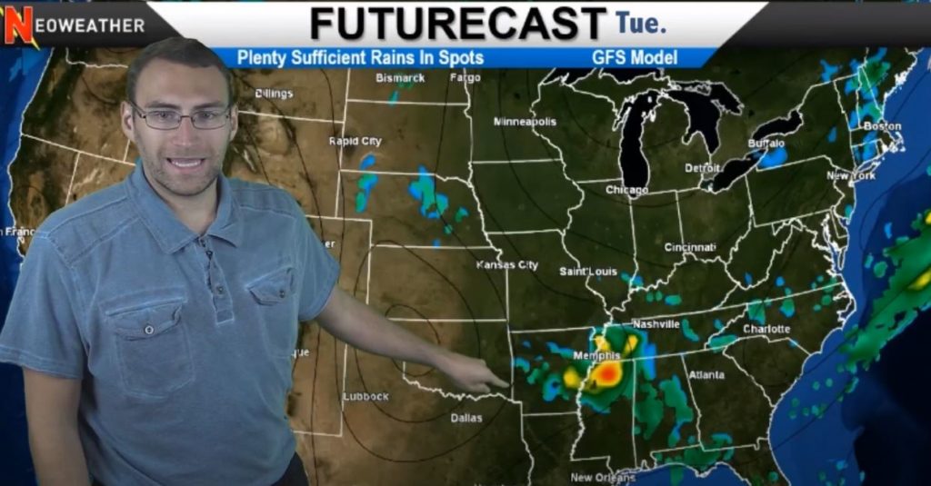
The air will stay dry over the Great Lakes and most of the country. There will just be small pockets of scattered rain that are very spotty. The only organized system of precipitation is expected to brew up on Wednesday smack in the middle of the country, but it fizzles out before it spreads too far East.

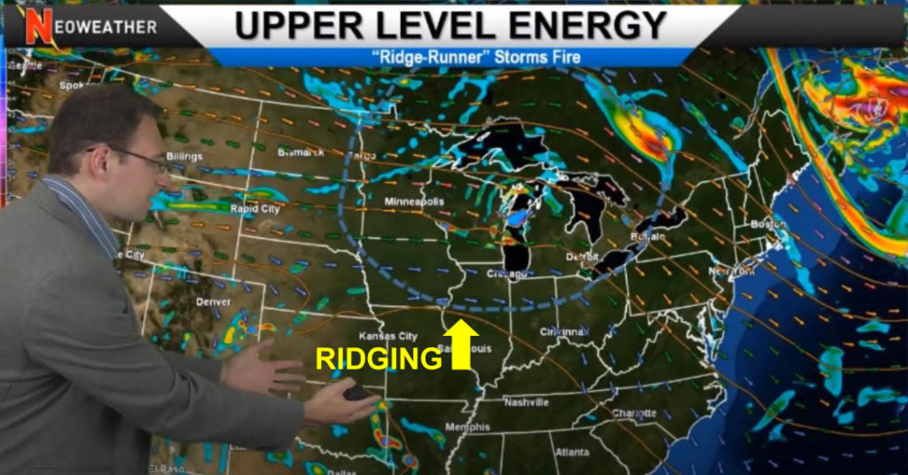
The only possibility of real rain activity might be from a ridge runner coming down from Canada and colliding with the high pressure system heading north. If that cool, low pressure air smacks into the high pressure air in the south, we might see some action. Otherwise we expect to see a pretty dry, mellow week in weather.

Dry Weather Map for this week

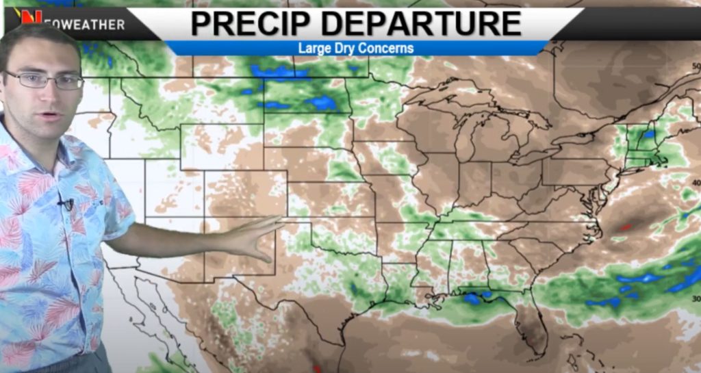
The only areas with precipitation potential this week are along the Canadian border (where the low pressure collides with the high pressure) and perhaps parts of Florida. The rest of the country will be mostly dry through July 10th.

Looking for customized forecasts to help you run your weather-dependent business? Contact Neoweather for details!

Will There be a Dust Invasion? Find Out!

There’s a monster dust storm whipping up a mess in the Caribbean that’s moving north towards the United States. It’s called a “Saharan Dust Layer” and it’s not something we see a whole lot in the U.S. but it actually happens a few times every summer worldwide. What is it and what will it do? Watch the video below or keep reading!

6/24/20 Weather Forecast Video from Neoweather

So what’s up with the Saharan Dust Layer? It’s actually dust and sand particles pulled up from Africa by the trade winds and pushed out over the Atlantic Ocean. Those winds will push a mighty swarm of particles into the Caribbean and into the Gulf of Mexico. It will then dissipate across the United States getting further inland than you might think. Meteorologist Brian Ivey is super geeked out about it, and if you are in those areas, your Covid-19 face masks may come in extra-handy!

Actually, the Saharan Dust Layer might seem like a dangerous thing for air quality, but most of the dust stays 5,000 to 20,000 feet above land so it doesn’t usually hinder breathing or irritate people with allergies. In fact, it has some good effects instead… It helps reduce the threat of tropical storms for a bit by adding a layer of very dry air to the atmosphere, plus it brews up some awesome sunsets so keep an eye out for that!

June 2020 Saharan Dust Layer from Africa

Precipitation Forecast

We’ve seen quite a bit of rain over the last couple of weeks in the East and Upper Midwest. Other parts of the country have been very dry. This week is expected to be pretty quiet as well across most of the U.S. until the weekend when we could see some rain in the Ohio Valley and portions of the West. Tuesday a more significant system is expected to kick up some heavy downpours in the Memphis area. The precipitation is expected to remain scattered – primarily in the Ohio and Tennessee Valleys.

Aside from the excitement of the Saharan Dust Layer sweeping across the United States, it’s not expected to be an exciting weather week. Just watch for spotty rain and the potential for storms around Memphis early next week.

6/3/20 Weather Map

If you have a business that depends on accurate weather forecasts to be your most profitable, consider customized forecasts from Neoweather. The weekly forecasts we give you here are generalized and long-range, but Neoweather can give you private forecasts for YOUR specific service area so you dispatch your team at the right time, with the right materials and equipment. Contact Neoweather today for more details or a quote.

This Week’s Weather & Summer Forecast Preview

If you are in the Upper Midwest, Kansas City region, or around the Gulf of Mexico, you are going to want to pay extra close attention to the weather this week. Storms are coming and some might be a bit concerning. See Brian Ivey’s forecast and a sneak peek at Summer 2020 expectations below.

6/2/20 Weather Forecast from Neoweather

Today or tomorrow there is a risk of threatening weather in the Upper Midwest region including the Dakotas, Nebraska, Iowa, Minnesota, Wisconsin, Illinois, Michigan, and the Ohio Valley. That system brings the potential for rain and the possibility of severe storms in some spots.

The key weather term of the week is “ridging.” The big area of ridging in the Midwest means the weather starts off quiet this week, with high pressure that keeps skies relatively sunny in most of the country. Then the troughing on the edges of that ridging can cook up some nasty storms. That’s what we’re likely to see this week…. storms popping up on the edges of the ridging. All the action and energy this week is north of the ridging.

Weather Map Showing Ridging

By Thursday the ridging and troughing activity will have moved through and Neoweather expects us to see much more of a scattered rain situation. Those rainy systems are unorganized but seem to start off over the eastern half of the country first, then the western states get some precipitation too by the weekend. Nothing is expected to be severe aside from the Tropical Storm that’s kicking up in the Gulf of Mexico. The trajectory on that storm looks like it will collide with the Gulf Coast and Florida by Saturday. Most of it will cover the Florida Panhandle.

Monday is expected to bring a cold air blast to the Pacific Northwest which will cool things down a bit. There may even be some snow in the higher elevations. This overall cooling will last a week or so in that area, while the rest of the country remains warm.

Summer 2020 Expected Temperatures

Summer 2020 Temperature Expectations Map
Summer 2020 Temperature Expectations

A warm summer with relatively mild temperatures is expected this year. You can see from the map above that there are areas of slightly above or below average temperatures, but the only area expected to be well above average is the West Coast – specifically California and Utah. The rest of the country should only have mild variations from averages overall.

Looking for detailed weather forecasts built just for your weather-dependent business? Neoweather can help.