Looking for a faster way to measure parking lots, driveways and sidewalks? Check out Go iLawn for a super simple property measuring and bidding tool. Go iLawn combines high resolution photographs, measuring tools and updated property information in one easy-to-use application. Save time and money by getting accurate measurements for bids from the convenience of your office! How does it work? Just enter an address, business name or street intersection to locate a property and Go iLawn will return a property photo to you. Then, with a few clicks of the mouse you can measure any outdoor surface on the property. Save all of your measurements to an Excel spreadsheet and property photos as jpeg files to your computer.
Go iLawn uses high resolution aerial photography (taken from a plane). Their photos are clearer than a standard satellite photos because they are taken much closer to the earth with a high resolution camera. Plus, most images are taken after the leaves have fallen off of the trees so tree canopies don’t obstruct the view of the surface you need to measure. They have 100% coverage of the U.S. and Canada, so no property is left out! The age of the photos varies by county. Typically aerial photos are taken per county request.
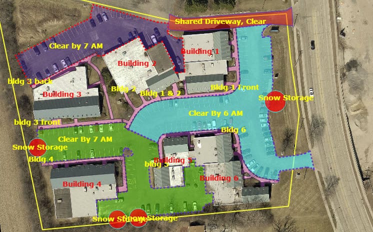
You can measure any outdoor surface for any property type on Go iLawn with their simple measuring tools. They have several easy-to-use tools to help you measure property features like sidewalks, obstacles, ramps, parking spaces etc. There are also annotation tools to help you call out property features or make important notes. You can zoom in close to plan your routes and equipment before you ever see the property in person!
How is Go iLawn Different from Google Maps?
It may seem like Google Maps is similar to Go iLawn for measuring properties, but there are many differences.
- Go iLawn images are taken from an airplane and Google’s photos are taken from a satellite image. This makes for a dramatic difference in the quality and view of the property. For example, images taken in winter show more of a property because leaf coverage is reduced. Also, high resolution cameras take much better images that you can zoom way in on that satellites.
- Powerful measuring tools come with Go iLawn. Go iLawn’s Drawing Tools, Groups, and Data Preservation are powerful tools to help turn the Pictures you look at into Data you use to build a Systems-Driven company. We don’t know of ANY other system that gives you this power to build a data-based model of your jobs.
- Customer support. Google isn’t meant to be used for measuring, so good luck getting help from them for that purpose. Go iLawn is supported by experienced professionals and training is included too.
- Many more differences… include closer zooming for more accuracy with Go iLawn, multiple views are available of a job site, and in a nutshell – it’s specifically made for the purpose of measuring properties to give estimates!
Go iLawn gives you something you don’t get anywhere else because of the unique way it combines mapping, drawing, displaying, and saving capabilities.