Here it is – Neoweather’s forecast for the much anticipated winter storm hitting the country both before and after Thanksgiving this week! Looks like Midwest and Ohio Valley snow contractors will have to warm up their plate of turkey after some pretty hefty snow clean up. The big news on top of that is the wind. Expect to see gusts up to 60 miles per hour in some areas. Then there’s a reboot storm for the Northern states on Sunday.
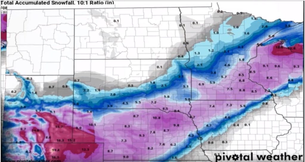
According to Brian Ivey of Neoweather, the fun starts with strong winds in front of the snow corridor today. The high winds cover Northwest Texas and the Ohio Valley, while the snow band is expected to stretch from the Rockies to across Southeast Minnesota and Northwest Wisconsin. The snow starts in the Rockies (of course) and will move Northeast from there covering Nebraska, South Dakota, Northwest Kansas, then into Iowa, Minnesota, Wisconsin and the Upper Peninsula of Michigan. It lifts north as it moves east across these areas. The snow will be significant, but not to the level of a huge blizzard in the United States. Most of the snow band areas will see up to 5-10 inches. The Rockies and U.P. will see over 10 inches, so get ready to dig out there! There will be lots of rain and winds in front of that system for Michigan, Ohio and the Eastern states.
The big time winds are another story in and of themselves. There will be widespread gusts of 40-50 miles per hour across much of the Midwest and Northeast. The lake shores may even see up to 60 mile per hour gusts through the day on Wednesday, into early on Thursday. Don’t be surprised if the Macy’s Thanksgiving Parade floats have to stay low due to the winds in New York City.
Second Snow System this Week
Ready for round two? Another system builds up on Friday in the Rockies just as Black Friday shopping is wrapping up for the day. This time it starts in the Southwestern area of the Rockies but moves north rapidly to pound the Dakotas and Minnesota with blizzard conditions over the weekend and early next week. As it hits the northern air of Canada, the system curves down and weakens a bit while it moves over the Great Lakes and into the Northeast on Sunday and Monday.
Looking for accurate weather information that helps you run your snow business? Neoweather builds custom forecasts just for you with hourly data that includes dew points, snow totals, temperatures and more! Stop relying on generic weather apps that can waste your money by having your team deployed too early or too late. Contact Neoweather for a quote!