You’ve already gotten a taste of winter 2019/2020 but what’s going to happen as it continues? What are the models saying for December, January and February this year? Here’s your official nationwide long range winter forecast from Neoweather. Meteorologist Brian Ivey takes a look at the general overall weather pattern looking at the models with the best historical track record to give you a long range forecast for our country. Check out other Snow Plow News blogs for regional long range forecasts.
The jet stream will bring plenty of cold weather across the middle of the country and then up into the Northeast. However there will be an area of high pressure over the west coast that keeps temperatures potentially well above average. No El Niño or La Niña are expected this year but we do expect a Negative Eastern Pacific Oscillation (EPO). That means there will be an area of warm, moist weather from the Pacific states that may collide with the cold jet stream as it moves east. This could setup a major winter battlefield in the Midwest and Northeast regions. In other words, the temperatures in the western third of the country are expected to be 2-4 degrees above average, especially in the Nevada region where it will be the warmest.
The weather in the Midwest and Northeast will be 2-4 degrees cooler than average, especially around the Great Lakes. When those worlds collide, that’s when the snow events will happen. The Midwest and Ohio Valley will feel those effects with higher than average snowfall this year – but might not be as much as last year. But look out DC, New York and Boston – you may be in a big time snow zone this winter with as much at 150% above average snow fall!
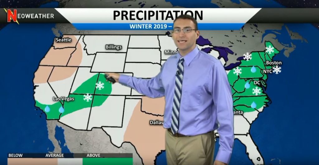
Most of the country is going to be at average precipitation this winter. The exception is the Northeast from Atlanta on up. They will have above average snow fall. The other area to watch is Southern California for above average rain that will turn to snow in higher elevations around the Rockies. Expect drier weather than last year in Seattle and the Northern Pacific states and in the Southern Plains.
Looking for more long range forecasts? Check out other weather forecast blog posts from Neoweather brought to you by Snow Plow News!
Interesting map. I’ve done climate study since the 70s so I stay up to date with a lot & look at a lot of forecasts etc. I think this guy is very close to really correct. I know, mets base winter Dec, Jan, Feb months. I go by the calendar & a cold vs warm season. December 21st is often first day of winter with cold season Oct to April etc. I always figure early Dec is late autumn & March can be very wintry even in South. March was when the South got its biggest snow in the blizzard of 93. I’m familiar with Duluth, MN weather. If you like cold or snow even with a warming earth, you get it every winter there & will for decades to come. If you love heat with humidity, Orlando is your spot. As for the winter forecast in this video, I believe if he makes the cold areas adding just a little more to the West & South, that would be perfection. I’d suspect below average as in entire winter combine as far down as Macon but not FL. As for precip, same thing a little more South just South of Atlanta & then a little more West included but every area he has. I think TN is going to be in the news a lot this winter. That’s a Southern State yet in a location North enough that it can get Northern winter type periods unlike Atlanta. I think there will be Gulf systems moving up this season. That Atlanta Northward area is always on the line it seems. I think just North of Atlanta it’s going to mix up with not only rain but sleet, freezing rain & three big snows. Big for those areas that is. The ice storms will be big news imo & then those systems move up East Coast with big snows imo I also expect a seesaw type winter in all his blue areas. That means times of zonal flows for average then even some above avg days & a return to longer times of below avg days that averages just about how he made forecast. I think he made a great forecast & I’m always picky about it all. I’m not thrilled with Joe Bastardi right now per forecasts but he’s good too. He need to leave politics out of his weather.