Special Weather Alert: Get ready for a smorgasbord of weather this weekend that will demand attention with extreme snow, ice and rare down pours that are likely to cause flooding in parts of the country. It’s not just isolated to the upper Midwest either – Mother Nature shares this dish with most of the family…
Things kicked off with a swirl of activity across Southern California and the Desert Southwest. Those heavy rains moved towards the Northeast and are bringing a cluster of madness as it collides with cold Canadian air coming down from the North and warm Gulf Coast moisture heading north. That system will set up BIG TIME weather events with a huge temperature range and all types of precipitation that will create severe weather starting Friday. That will include tornadoes and damaging winds with hail across Texas, Louisiana, Arkansas and Mississippi on Friday. Then it will move eastward into Alabama and Georgia Saturday.
On Saturday, the northern side of this system will bring big time flooding rains moving across the Ohio Valley region. Areas of Missouri, Illinois, Ohio and even Southern Michigan could see up to almost 5 inches of rain with 2-4 inches being widespread. Central Illinois will get the most rain. This is a VERY rare event for January – don’t you feel lucky?? The northern edge of this rain will be freezing, so be careful out there. The ice storm will skirt the Canadian/U.S. border as it moves through the area.
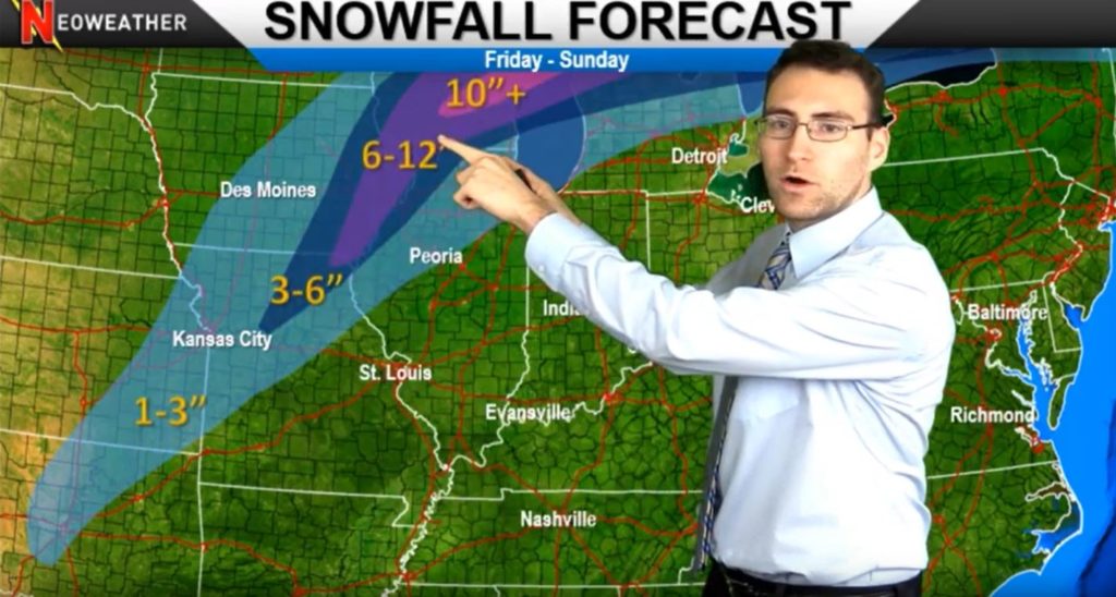
The snow zone on this system starts in Kansas City and travels a clear NE path from there up through Iowa, Northern Illinois, Wisconsin and into Michigan. This baby will bring up to 12 inches of snow over the weekend so dust off those plows, Upper Midwest, the snow is back and this time it’s serious! No need to fear, New England, this system is going to head up into Canada and you should be spared this time. But watch out, Ontario and Quebec, you’re getting slammed with 10, 12, maybe even 15+ inches of snow!
On top of this dramatic mix of precipitation, we expect to see gusty winds up to 30-40 miles per hour. So between all the rain, tornadoes, hail, ice and snow mixed with high winds, this will be a weekend to watch out – where ever you are in the country.
If you want a more customized forecast for YOUR service area, contact Neoweather today. The forecasts we bring you from Neoweather are widespread, but what they really do best is custom forecasts with your company’s needs in mind.