Monthly Archives: May 2020

Weather Battle Royale: Spring vs. Summer

The heat continues from coast to coast early this week, with well above averages across the country until Thursday. Then some rain sweeps through the east Thursday and Friday. The weekend brings lots of sunshine, but we expect to see much cooler temperatures over the weekend. See all the details from Brian Ivey at Neoweather below!

2/27/20 Weather Forecast from Neoweather

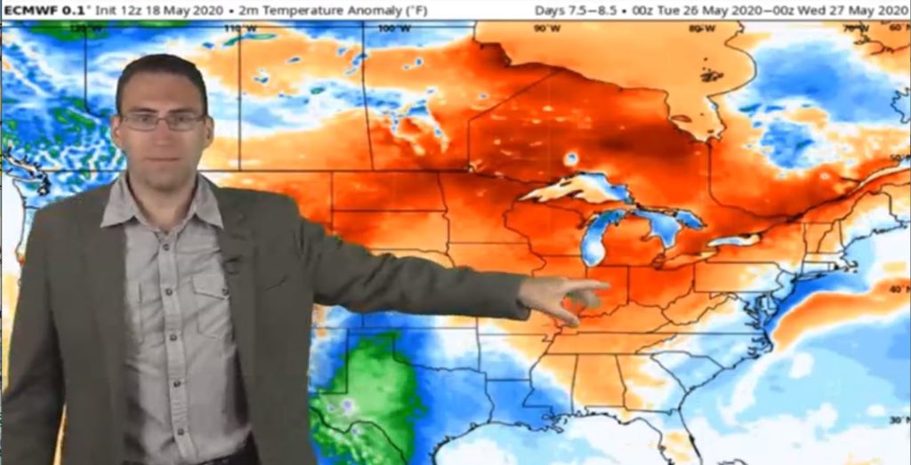
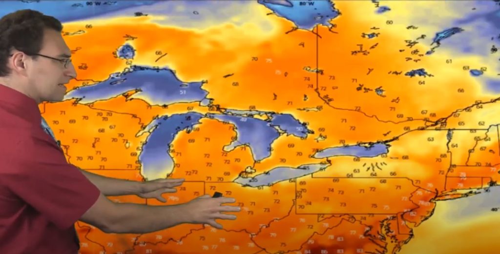
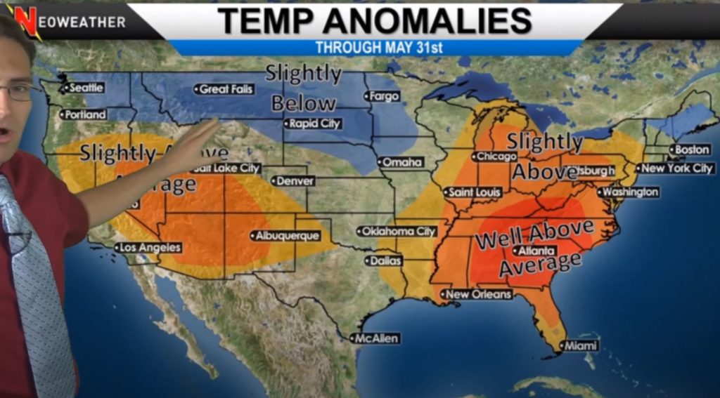
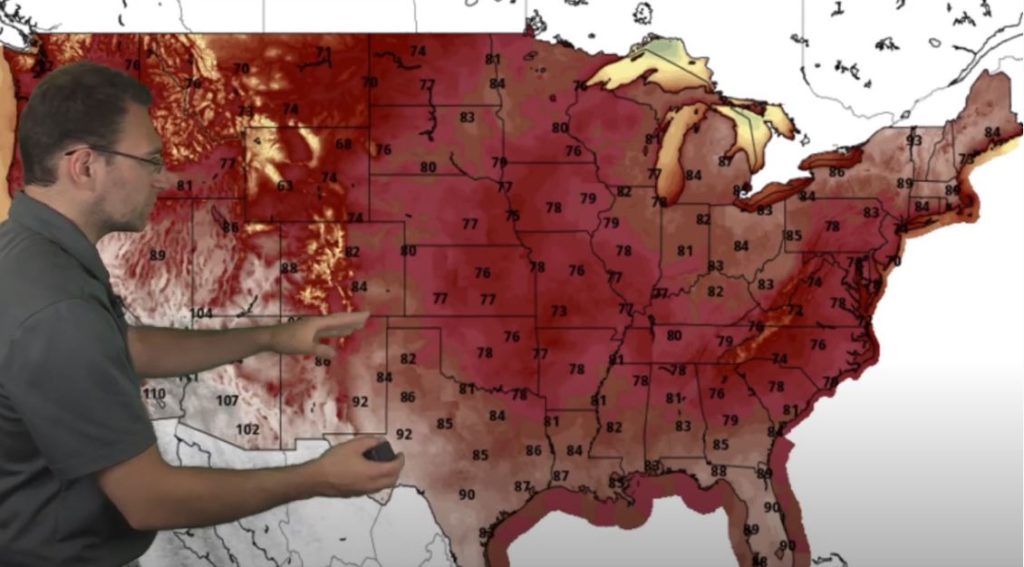
The unseasonably warm weather continues through today and into tomorrow across nearly every state in the Continental United States. Some areas are seeing well above average temperatures, while others are just seeing slightly above average. Even northern areas like Fargo, North Dakota are seeing highs around 84 degrees today!

5/27/20 Weather Map

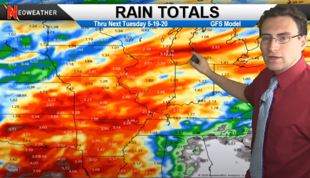
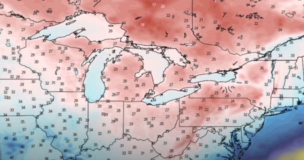
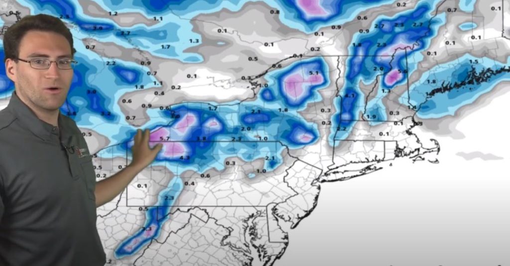
The rainy parts of the country today are isolated to the Tennessee Valley and North Carolina, moving northward. That system kicks up into the Great Lakes region by Thursday and becomes more widespread. The wet air is followed closely by much cooler temperatures in those areas for Friday and the weekend. We expect a 10-20 degree dip in the highs Saturday and Sunday in the Upper Midwest into the Northeast. The cooler air is coming down from Canada and is expected to be dry. If you live in those areas, it’s a great weekend to finish up your spring yard work without it being too hot or wet.

6/1/20 Dry Weather Map

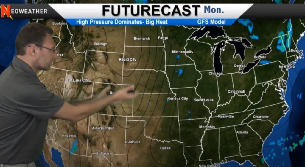
Next week is expected to start off dry as well with the high-pressure system and cooler temps sticking around for at least a few days in the northern areas.

However, a warm system is expected to come up from the south by Tuesday to warm things up again in the middle of the country. That’s when the battle begins for Spring vs. Summer temperatures as both the East and Northwest coasts stay cooler.

Looking for customized weather forecasts to help you make wise business decisions about your company? Check out Neoweather today!

Widespread Rain Douses Most of the Country – See Details!

Get ready to watch the grass grow to new heights this week when most of the country welcomes bucket loads of rain and unseasonably warm weather.

5/19/20 Weather Forecast from Neoweather

This week starts off with significant bouts of moisture coming up from the gulf running along the eastern portions of the country. Tropical Storm Arthur prevents that system from moving out to sea, so it hangs around dropping lots of rain and causing some flooding in the Tennessee and Ohio Valleys. Indiana, Illinois, and Michigan also get significant amounts of rain. The Southeast and Mid-Atlantic regions see the heaviest rainfall over multiple days.

More rain is also expected throughout the week in the Pacific Northwest, but it won’t be significant like in the Southeast. Central United States is quiet this week until Friday when some rain pops up in spots there as well.

As the weekend rolls in, isolated rain is expected across most of the country. These won’t be strong or large systems, just a peppering all around the country of small pockets of rain. The bigger story this weekend is the unseasonably WARM weather – that’s right, for once we aren’t talking about snow! The warm temps are expected to last into early June.

Late May Weather Temps Map - Expect Warmth!
Late May Weather Temps Map – Expect Warmth!

Starting this weekend we expect to see widespread 80s and high humidity in most of the country starting this weekend and through the rest of May. The only areas expected to see average temps are in parts of the North, Texas and along the East Coast for a bit. The rest of the country is in for a warm-weather treat.

If you would like to get the best information possible to make weather-related decisions for your business, consider contacting Neoweather today. They do an excellent job of preparing customized forecasts just for YOUR service area, with answers to the specific weather questions YOU need to make informed business decisions.

Is Winter Finally Over? See for Yourself!

After record-breaking snow last weekend, it looks like we’re finally in store for a weather pattern change this week as May wraps up and winter may become a memory. We expect to see lots of rain and moisture, but nothing too serious as most of the country slips into slightly above average temperatures (with the exception of the North Dakotas region).

5/12/20 Weather Forecast Video from Neoweather

This week still starts out chilly for the upper Midwest and Northeast. The nights are especially cold with lows in the thirties. But on Friday things take a swing in the opposite direction as a true pattern change moves in. Warmer than average temperatures – and even MUCH warmer than average – are expected to move in Friday in the Ohio Vally and much of the Midwest. It will finally be true Late-May/Early-June weather! So cold tries to push down from Canada over the weekend and next week, but it’s still much warmer than where we’ve been. We might even see highs in the low eighties by the end of the month!

5/15/20 Weather Temperature Map

After the cold moves out, the rain moves in… Sorry, but that’s next on deck. The systems are relatively isolated across the country, but they will be active and bring in healthy doses of rain to many areas. It starts off today and tomorrow with systems in the Tennessee Valley and the Pacific Northwest. As they move west, they will bring areas of rain and low pressure through the rest of this week to the Midwest and Ohio Valley as well.

Up to 5″ of rain through next Tuesday

The warmth and sea surface temperatures are ripe for building up a tropical storm off the coast of the Carolinas. Doesn’t look like anything that will wreak havoc, but just something to watch as it hopefully stays out at sea. As we go into early next week, most of the nation is relatively quiet.

The temperatures for the rest of May are expected to be above average for most of the country with just the very northern areas predicted to be slightly below average. Notice the hot spot around Atlanta where temps are expected to be well above average.

Temp Anomalies through May 31, 2020

If you would like to get the best weather information possible to make informed decisions about your business, get a quote from Neoweather today. They can help you make sure you send out your crews at the right time with the right materials to be most cost effective!

May Snow & Cold Could Break Records!

The calendar might say May, but Mother Nature is still serving up cold temps and even snow in the Midwest and parts of the Northeast! Did she not get the memo?? While the temps are warm out West and in the South, there are big dips in the jet stream up North that are bringing in some very cold winter air down from Canada. See what Brian Ivey (with his ever-growing quarantine hair) has to say about the weather this week below…

Today and Thursday we’ll see average temperatures in the West and Southeast, up into the Ohio Valley. We expect to see some scattered rain, but nothing serious. But get ready to bundle up this weekend if you are in the Great Lakes or Northeast. Temperatures will dip into widespread twenties across most of those regions on Saturday morning! There will even be actual snow! So don’t get too anxious and start planting just yet. You may need to wait a week or two before getting those annuals into the ground.

Map showing widespread temps in the 20's on 5/9/20
We expect widespread temps in the 20’s on 5/9/20

Accumulating Snow??

Brian and his team are watching several different models to see what might happen this weekend regarding possible snow. That’s right! We’re not just saying that to suck up to all you snow contractors – there might be actual accumulation this weekend when the troughing temps collide with the moisture in the atmosphere. The chances of real accumulation depend upon the track and timing – for flakes to add up, they’ll have to fall overnight when the temps are coldest. But they’re expecting anywhere from under an inch up to 5-7 inches in some isolated spots across northern Pennsylvania and New York.

Check out the potential snow map for Friday & Saturday

5.9.20 Snow Map

The snow front has rain expected before and after it, so it won’t last long even if accumulation occurs. Other bouts of rain are expected to hit parts of the country this week, but nothing severe to cause more storms or flooding like in recent weeks. Most of the country is not expected to see typical warmer temps until mid-May. The major cold on the Northeast and warmer than average temps in the West are expected to continue for the next week or so.

Looking for extra insurance that you are sending out crews at the right time, with the right equipment and supplies? Check out a custom forecasting service like Neoweather today!