Monthly Archives: January 2020

Grab a Snow Shovel for Punxsutawney Phil – He might need to dig out on Groundhog’s Day!

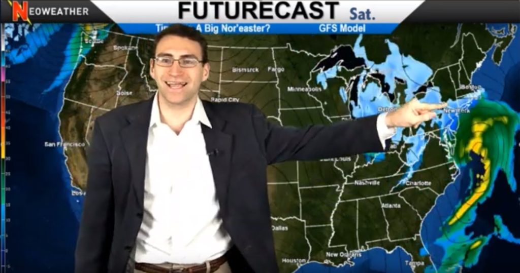
This week kicks off with average to slightly warmer than average temps across most of the country but that’s going to be followed by a dose of much colder air behind it. Watch for a huge downward temperature swing on the heels of that warmer system that could stir up a bonafide Nor’easter on Groundhog’s Day.

1/28/20 Weather Forecast Video from Neoweather

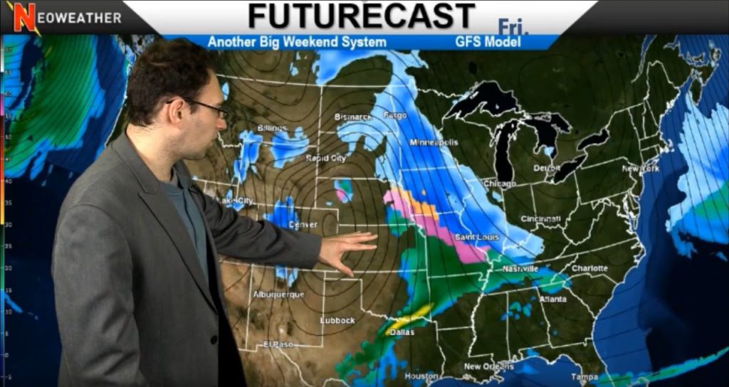
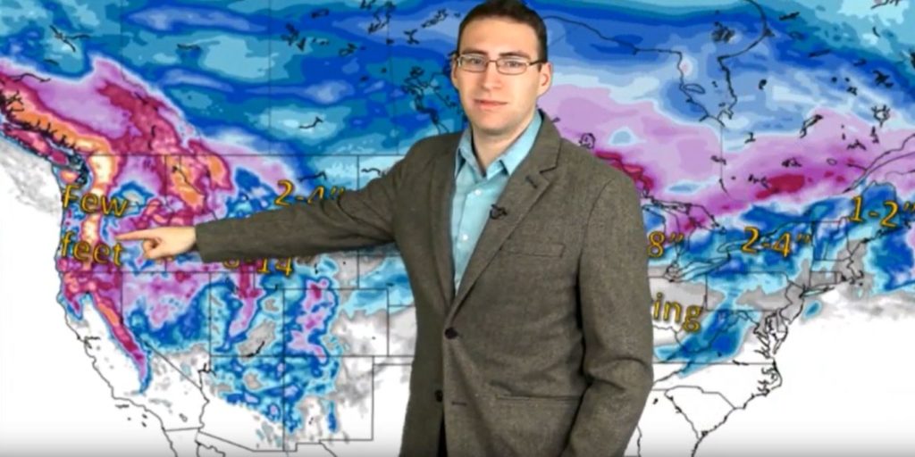
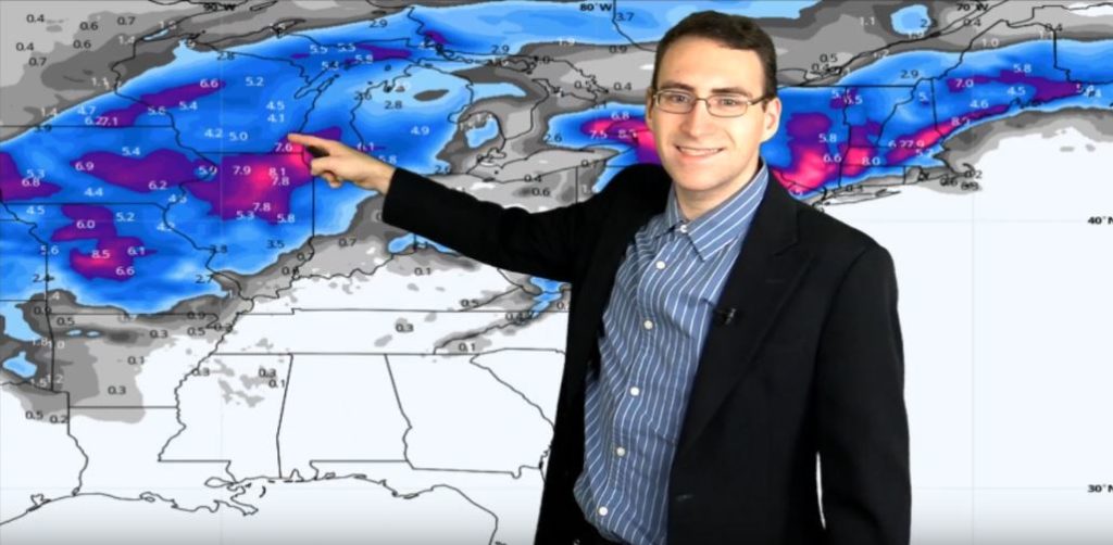
The long range forecasts have been tough and more unpredictable than usual due to conflicting models and a lack of any real signals about pattern changes. But as for this week and into next, we can be confident about what’s on the way. Today we are seeing snow much further south than we’ve seen lately with flurries across most of Missouri spreading east into West Virginia before it hits some drier air and dissolves before the weekend.

Speaking of the weekend… We could see a big time Nor’easter bust out on Saturday from a system that will be moving across the Great Lakes region. If that system of much colder air collides with the moist warm air coming up the coast from the South, Punxsutawney Phil might need some snow removal services before he can crawl out of his hole on Groundhog’s Day.

2/1/20 Weather Forecast Map from Neoweather

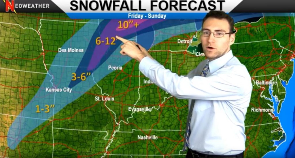
Next week Brian Ivey expects to see another Intermountain West system hit the area on Monday and move across the country early next week. Looks like the main recipient of that snowy gift will be the upper Midwest and Great Lakes area again, so if you are in those areas, re-stock your ice melt supply and get ready for go time once again.

1/28/20 Weather Map Showing Moisture & Precipitation
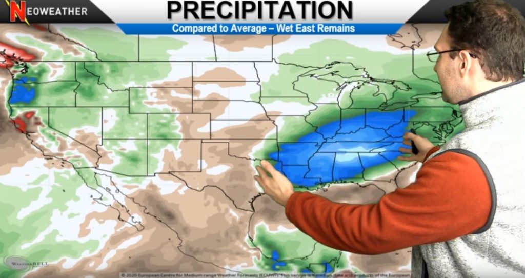
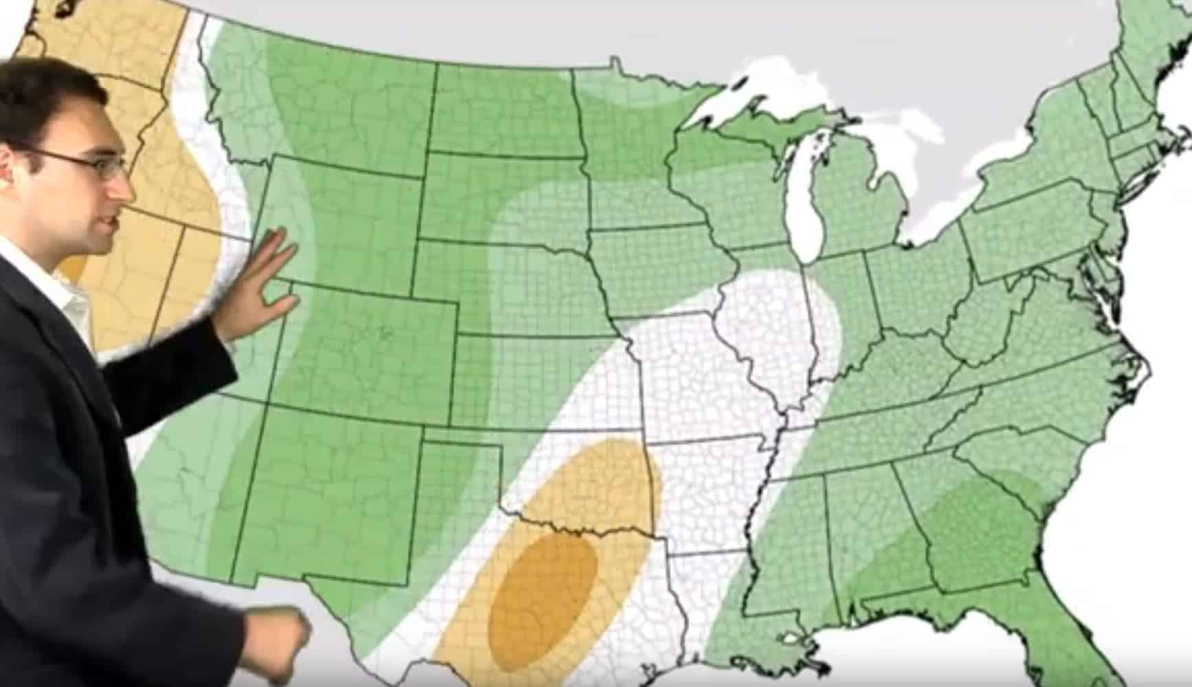
While the exact long range systems have been hard to predict, Neoweather’s team does have pretty high confidence about the systems on the way based on the above average moisture and precipitation pattern in most of the country (shown in shades of green), especially in the middle of the country and in portions of the East.

If you need to make good business decisions based on the weather that will either cost or save you thousands of dollars, get direct access to your very own team of professional meteorologists by signing up with Neoweather. Ask around and you will find out that the investment into private forecasting services is well worth the savings. Contact Neoweather for details!

Toro Takes Another Step Forward in the Snow Industry

The Toro Company just announced yesterday that they are diving even deeper into the snow and ice management world by acquiring Venture Products, Inc., manufacturer of Ventrac Products. Ventrac is a leading manufacturer of durable compact tractors that have a nearly unlimited assortment of attachments for all types of snow removal. A few years back, The Toro Company acquired Boss Snowplows, so they are no stranger to the Snow and Ice Management industry and seem to be focused on growing their presence in the snow contractor world.

Ventrac Snow Equipment - Being Acquired by Toro
Ventrac Snow Equipment – Being Acquired by Toro

Ventrac’s compact tractors have long been an industry favorite primarily for managing sidewalk snow. They are powerful and incredibly versatile. You can add just about anything to a Ventrac tractor, including a winter cab enclosure, a variety of snow plow blades and snow brooms, a snow blower, drop spreader and more! Ventrac will bring a powerful new product to the Toro line of equipment. We featured their 4500z and 3400 models last fall…

Ventrac Compact Tractor Video

The Toro Company was once considered primarily a turf maintenance, but over the years they have massively expanded their product offerings to include snow management, landscape, rental and specialty construction equipment, and irrigation solutions. The biggest news to our industry, of course, was their acquisition of BOSS Snowplows in 2014. Along with having snow plows in virtually every shape and size, BOSS also has the revolutionary Snowrator, plus a growing lineup of salt and sand spreaders, and box plows built for the snow and ice management professional. But really, we don’t have to tell you how important BOSS products are to our industry for big time snow removal, so adding Ventrac for sidewalk snow management is a perfect addition to Toro’s snow and ice management solutions.

“Ventrac is well recognized in the industry for its market-leading innovation and commitment to meeting the diverse needs of customers. This acquisition supports our growth strategy in the professional market with the addition of a strong brand and expanded product offering to customers in the turf, landscape, and snow and ice maintenance categories.  We have long respected and admired the Ventrac team, and we look forward to helping them grow on the successful foundation they have built in Orrville, Ohio.”

Richard M. Olson, The Toro Company’s chairman and chief executive officer

The purchase of Venture Products Inc. is subject to regulatory approvals and currently anticipated to close before the end of The Toro Company’s fiscal 2020 second quarter.  The purchase price is reportedly $167.5 million in cash, subject to certain adjustments. If you’d like to get more information about The Toro Company and it’s host of products, contact them today!

Rounds of Snow Sit & Spin in Midwest

Instead of today’s system kicking across the Midwest into the Northeast, it’s going to sit and spin for a while over the U.P., Wisconsin, Northern Illinois and parts of Minnesota. If the temperatures are high enough, this could produce some serious snow, but it’s not likely. Areas like Chicago will be in the mid-thirties, so a lot of accumulation isn’t likely, especially on pavement.

1/22/20 Weather Forecast Video from Neoweather

The winds that are normally there to push systems east aren’t there, so that’s why we’re getting the sit and spin action over the upper Midwest. We expect the system to bring 2-8 inches of snowfall hitting Chicago the hardest, but how much of it sticks to the ground is really dependent upon the temperatures in that area and the ground temperature. While you’ll need to get the plows out for clean up, we don’t expect it to be an all-nighter.

1/22/20 Snowfall Forecast Map from Neoweather

After the system is done spining in the Midwest it is expected to breeze over Ohio when the winds kick up again and hit the Northeast on Saturday and Sunday. It COULD turn into a decent system over New England this weekend producing up to 10 inches of snow in higher terrains or if the cold air moves down. Some lake effect snow is expected on the tail of this system on Sunday and Monday, but how much will depend on the cold air too.

1/20/20 warmer weather pattern map
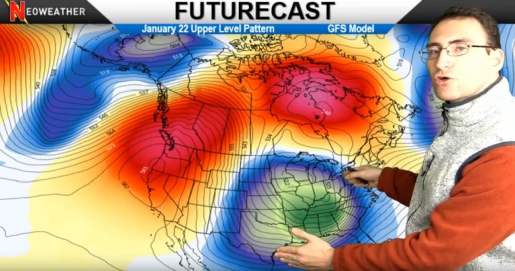
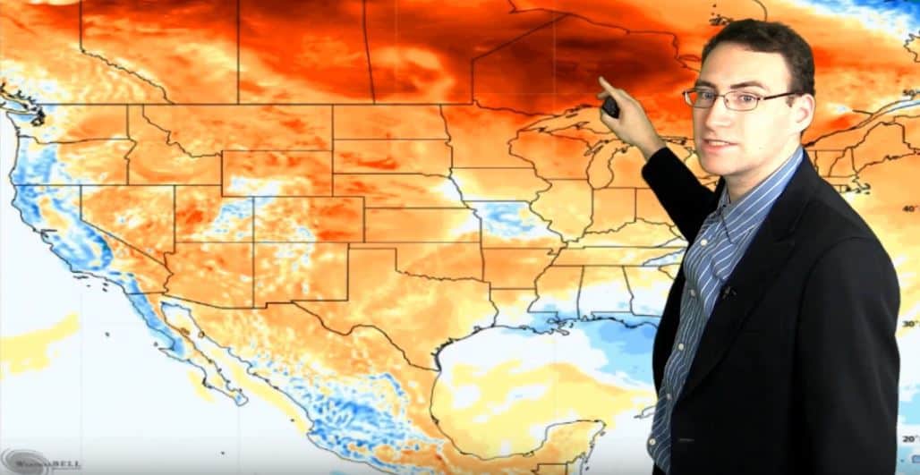
Monday we re-focus our attention on the Pacific Northwest for lots of rain in the coastal areas that creates some snow in the higher terrains as it moves west. In the mid-Mississippi Valley up into the Ohio Valley, we expect another warm up that will produce mostly rain at the beginning of next week. So much for the big pattern change we’ve been hoping for to keep the cold air locked in! Looks like more above average temperatures are on the way! Instead of wrapping January up with below average temperatures, looks like we’ll see well ABOVE average temperatures instead. Southern Canada is brewing up more transient warmth that will be the culprit for warmer weather the rest of the month.

With lots of winter season ahead of us and weather patterns always changing, it’s still a good time to consider a private forecasting service like Neoweather. General forecasts like the one you saw today are great, but where Neoweather can really help you business is by creating private forecasts just for YOUR snow removal or landscaping service area. Contact them today to see how they can help save you money!

Weekend Winter Wonderland – The Sequel

That’s right! Mother nature is working weekends these days! Last weekend produced a sizable rain, snow and ice storm around most of the country and this weekend she’s rolling out part two. Check out meteorologist Brian Ivey’s wintery weekend forecast!

1/14/20 Weather Forecast from Neoweather

The activity begins in the Southeast this week with active rain storms and a couple of clipper systems that move through the Northern Plains and Canada to the north and northeast. Wednesday’s snow in the Dakotas, Minnesota and Wisconsin will be a little more potent as it pushes through Yooper country on it’s way to New England.

Then our attention will turn to the Pacific Northwest area while an active system kicks up a lot of wind and precipitation near the coast. Higher elevations and areas to the east get snow on Thursday.

That Colorado low system brings in the highlight of this week’s forecast on Friday as it moves northeast across the country bringing in the weekend sequel of snow, snow, snow we mentioned earlier. It’s a familiar setup with snow and ice on the northern end of the country and heavy rains in the South. The activity stretches from the Gulf all the way into Canada so no one feels too left out on the eastern half of North America.

1/17/20 Weather Map from Neoweather

Based on most weather models agreeing, moderate to heavy snow is expected on the front side and norther side of this weekend’s system. It will move into New England on Saturday and bring lots of cold air on the back side for lake effect snow on Sunday. That cold will stick around at least for the beginning portion of next week. There will be a pattern change that will lock in colder weather for the rest of January. It’s not expected to be a monumental change, but we will see slightly lower than average temperatures over all for the rest of the month.

If you like these weekly forecasts, imagine having super detailed forecasts just for YOUR snow removal service area. Neoweather can help you save thousands of dollars by making sure you don’t send crews out too early and that you have the right strategy when conquering the storm. Contact Neoweather for details today!

Long Range Winter Forecast Update

Time for an update! Neoweather is looking at long range forecasts for winter 2020 again. They expected (and we received) a warmer than average December. That one’s in the books. What about January? Early on, most of the models agreed that it would be colder than average. So far, that hasn’t been the case… but wait for it. A pattern change is expected for the last week of January and into February where it will be colder than average as expected.

Winter 2020 Long Range Forecast Update

As you know, January kicked off with some big time warmth across most of the country. After a very NOT white Christmas, those above average temperatures stuck around for the first couple weeks in January over most of the country.

Why? Earlier long range forecasts were based on a weak El Nino being watched in the South Pacific. That was expected to expand and cause ridging between warm water and northern cold water causing a Negative Eastern Pacific Oscillation (EPO). But that didn’t happen and the EPO staying in a positive state so far this month. The models show that it may dip down at the end of the month, but it may not go as low as it needs to go for big impact. We’ll have to wait and see on that one. If the EPO stays positive, it will create a lot of uncertainty in the forecast.

Will January See Lower Than Average Temps Like Expected?

Short answer. Yes. But be patient. We do expect to see slightly lower than average temperatures near the end of January. However, those temperatures may stay in the north and will not necessarily be widespread or sustained over long periods of time.

Around January 22, models suggest that there may be a pattern change that helps the cold air from Canada move further down into the U.S. A cold pressure system will cause ridging that pushes the warm air down.

1/22/20 Weather Pattern Change Map

Will the new cold weather pattern lock in?

Neoweather expects that the cold weather will lock in after 1/22/20 but it may not lock in for long. The MJO Index and other weather models seem to show ongoing instability in the temps as we go into February. Models have some similarities, like the western half of the country is expected to dish up up to 10 degrees below average temperatures overall. However, the Midwest and Northeast are more disputed. Some models show 0-2 degrees below average temperatures for February in the Midwest and Northeast. Others show 10-14 degrees below average in the same areas. To see numbers like that the pattern change would really have to lock itself in.

What about Precipitation?

February Long Range Precipitation Forecast Map

Weather models indicate just slightly above average precipitation across most of the country with two exceptions: Drier than average in the Central U.S. and 2-5 inches above average precipitation in the Ark-La-Tex and Southeast (not including Florida which will be drier than average).

Looking for weather forecasts you can count on for YOUR specific snow removal service area? Whether you need long or short term forecasts, Neoweather can help! Contact them today!

Check out this Bad Ass Plow!

Will the Welder from Xtreme Fabrication reviews the new version of the SnowDogg MDII snow plow. There are some huge improvements on this new 1/2 ton plow. This plow is super versatile and can fit just about any sized truck like a glove. Check out the improvements on this baby!

Snowdogg improved the lift arm by going to a single chain on the MDII this year and moved to a drop down jack to make your job easier. They also made the light tower structure more rigid to eliminate shaking. What Will likes the best about these plows is the hydraulics. The pump and motor on the MDII is the same system they put on much bigger plows. Will the Welder says the hydraulics “are overkill for such a tiny plow, that’s why these things are so reliable.” So between the heavy duty single chain lift to the powerful, fully enclosed hydraulic power unit, the MDII plow will push through any storm. Key component features according to Snowdogg:

  • 1/4 in. grade 50 steel construction
  • Powerful lift cylinders
  • Over-sized 1-1/2 in. angle cylinders
  • Fully enclosed 2 HP hydraulic power unit
  • SAE standard cartridge valves and hefty 3/8 in. rubber hoses
  • Optimized hose routing
SnowDogg MDII 1/2 Ton Plow

SnowDogg Low Maintenance Snow Plow Blade

The Snowdogg MDII has a corrosion resistant 304 stainless steel moldboard that never needs paint. You won’t have to deal with rust and corrosion or painting maintenance with this plow! The robust plow frame was designed to spread the impact across the entire blade to reduce wear and tear on the vital components. You can’t go wrong with this plow if you are looking for something tough and versatile for a 1/2 ton truck, jeep or SUV! Contact SnowDogg today for more information!

Giddy Up Snowplowers! This weekend we ride!

Special Weather Alert: Get ready for a smorgasbord of weather this weekend that will demand attention with extreme snow, ice and rare down pours that are likely to cause flooding in parts of the country. It’s not just isolated to the upper Midwest either – Mother Nature shares this dish with most of the family…

1/9/20 Special Alert from Neoweather

Things kicked off with a swirl of activity across Southern California and the Desert Southwest. Those heavy rains moved towards the Northeast and are bringing a cluster of madness as it collides with cold Canadian air coming down from the North and warm Gulf Coast moisture heading north. That system will set up BIG TIME weather events with a huge temperature range and all types of precipitation that will create severe weather starting Friday. That will include tornadoes and damaging winds with hail across Texas, Louisiana, Arkansas and Mississippi on Friday. Then it will move eastward into Alabama and Georgia Saturday.

On Saturday, the northern side of this system will bring big time flooding rains moving across the Ohio Valley region. Areas of Missouri, Illinois, Ohio and even Southern Michigan could see up to almost 5 inches of rain with 2-4 inches being widespread. Central Illinois will get the most rain. This is a VERY rare event for January – don’t you feel lucky?? The northern edge of this rain will be freezing, so be careful out there. The ice storm will skirt the Canadian/U.S. border as it moves through the area.

The snow zone on this system starts in Kansas City and travels a clear NE path from there up through Iowa, Northern Illinois, Wisconsin and into Michigan. This baby will bring up to 12 inches of snow over the weekend so dust off those plows, Upper Midwest, the snow is back and this time it’s serious! No need to fear, New England, this system is going to head up into Canada and you should be spared this time. But watch out, Ontario and Quebec, you’re getting slammed with 10, 12, maybe even 15+ inches of snow!

1/11/20 Weather Map from Neoweather

On top of this dramatic mix of precipitation, we expect to see gusty winds up to 30-40 miles per hour. So between all the rain, tornadoes, hail, ice and snow mixed with high winds, this will be a weekend to watch out – where ever you are in the country.

If you want a more customized forecast for YOUR service area, contact Neoweather today. The forecasts we bring you from Neoweather are widespread, but what they really do best is custom forecasts with your company’s needs in mind.

Active Weather on the Way – 1/6/20 Forecast

Get ready for an active weather pattern that kicks off this week and will keep much of the country on it’s toes over the next couple of weeks. Nothing major for most of the country, but keep an eye out up north and in the Rockies!

Neoweather 1/6/20 Forecast brought to you by Snow Plow News

It’s Clipper City heading our way with minimally invasive cold air for much of the northern half of the country this week and into next. It starts with a small snow system skirting across the West Virginia mountain range into Maryland, while the Great Lakes region gets a bit of lake effect snow. We don’t expect more than a couple inches of accumulation. Then a couple more clippers build up in North Dakota and the Northern Rockies near the middle of the week. Most of the cold stays up in Canada with a bit dipping down into the upper regions Wednesday and Thursday. The warm air from the south will keep most of this cold pushed up into the north.

By Friday and Saturday we will see some significant precipitation, but that stays as primarily rain in most areas due to the warmer weather in the South. However, a strip of cold air on the western side of that system may be enough to bring some snow to the Midwest and Ohio Valley by this weekend in the Upper Midwest and Northeast regions.

Rocky Mountain Snow Expected Soon - 1/11/20 Weather Map
Rocky Mountain Snow Expected Soon – 1/11/20 Weather Map

Rocky Mountain Snow

Then things really kick up a notch in the Rockies and Northern Cascades on Sunday due to the wet air meeting the colder temperatures. Over the next two weeks, we’re expecting some significant systems in the higher elevations that could amount to a few feet of snow in those areas. Depending on where the cold air lines up, that snow could amount to 4-8 inches in the Great Lakes area and 2-4 inches in New York once it moves east.

Overall we’re expecting an active pattern, but not a widespread concern for serious snow across the nation. Looking for accurate weather forecasts for YOUR service area? Consider Neoweather private forecasting for your snow removal business!