Monthly Archives: December 2019

New Year, New Decade, New Snow? See 12/31/19 Forecast

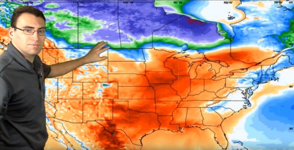
2020 greets most of the country with cold weather and some snow initially, but that dies out quicker than a new year’s resolution! By this weekend, the Central and Eastern U.S. will have higher than average temperatures reminiscent of December 2019. Although the Southeast will get a little pop of colder weather. That will be short lived, then we will be looking at a scattered outlook across the country with nothing too noteworthy.

12/31/19 New Year Forecast from Neoweather

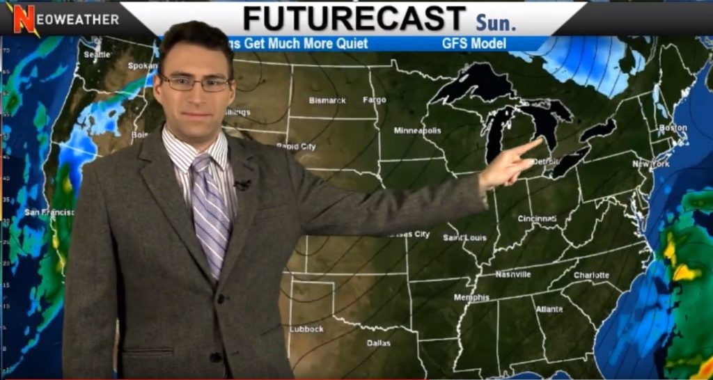
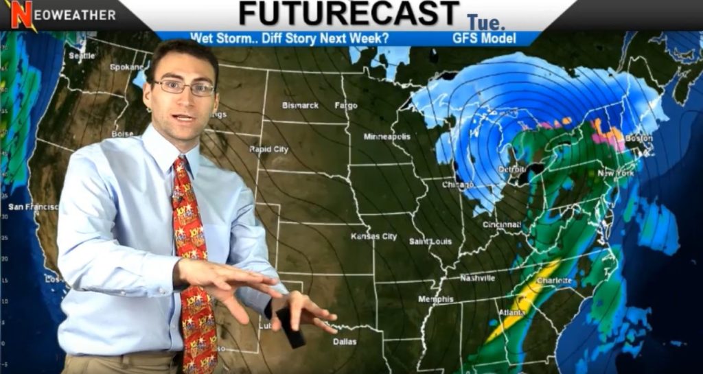
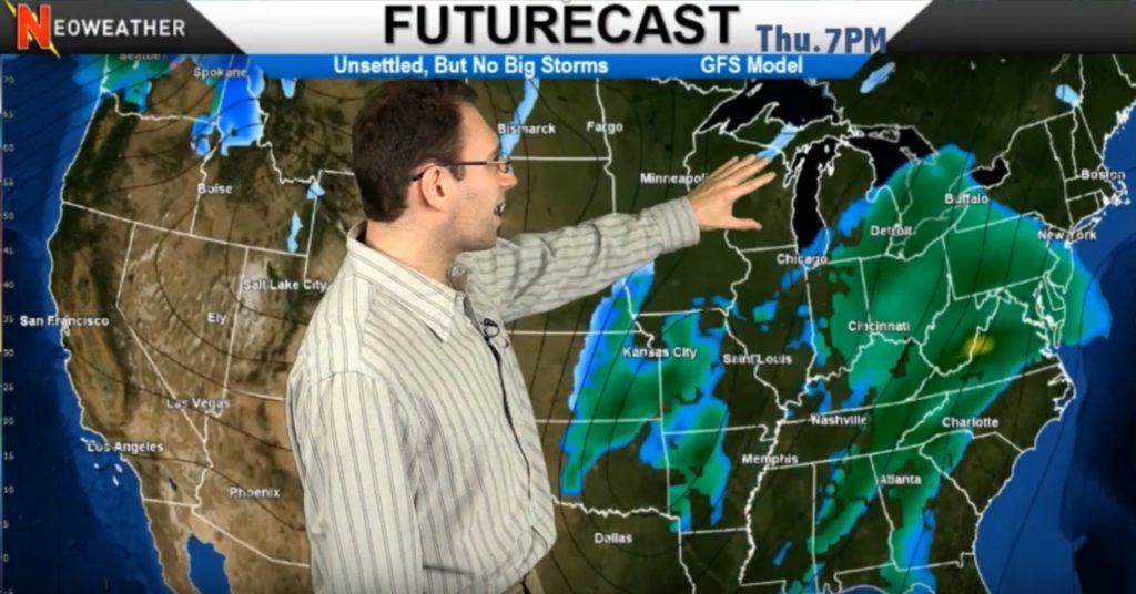
After a few inches of snow hit early today in the upper Midwest, the system will move through to the Northeast on Wednesday. A little lake effect snow will hit that region with an inch or two, but nothing major. A system in the Intermountain West will kick up some snow for a few days. Late in the week a system builds up in the deep south in Texas and Louisiana that will move up into the Ohio Valley, Great Lakes and into the Northeast – but no need to prep the plows because it’s only expected to be rain. However, the backside of that system is likely kick up a little bit of lake effect snow on Saturday for the Great Lakes states like Wisconsin, Ilinois, Michigan, Indiana, Ohio and into the Northeast. This is not going to be a boring week and weekend – there will be snow events in the Upper Midwest and Northeast, but they won’t be extremely large.

12/31/19 Weather Map

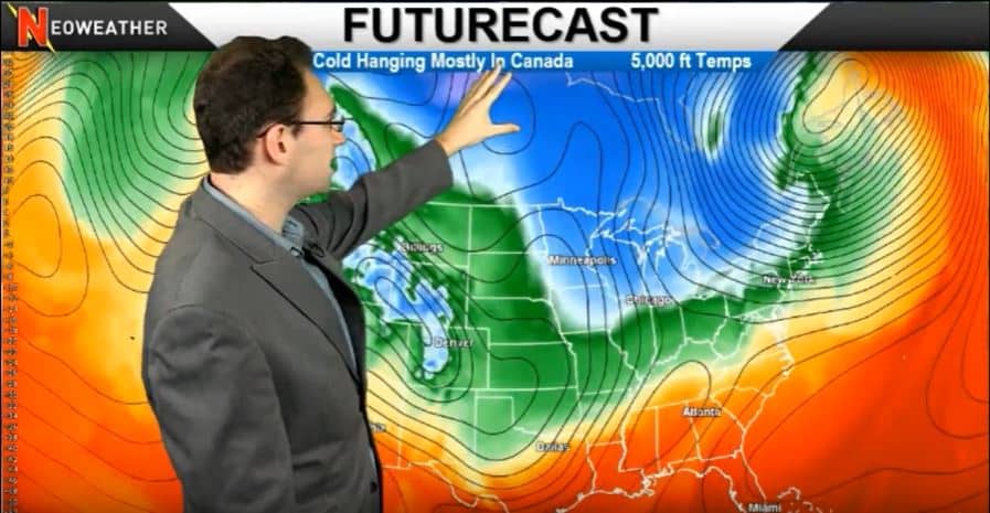
Next week there will be a brief break in the weather, then a hit and miss pattern of cold and snow. The Rockies will likely get some snow, but nothing major is expected. The source of the cold will stay further north and into Canada, while the Pacific jet stream will keep things on the mild side for most of the southern United States. There will be a couple of cold days, but there are no indications that it will last long or that there will be anything major as far as winter storms.

12/31/19 Weather Map from Neoweather

Looking for accurate long and short term weather forecasts just for YOUR service area? Contact Neoweather for private forecasting services that go well beyond the details you can get from generic apps and local forecasters.

Winter Settles Down – 12/17/19 Forecast

Rise and shine Ohio Valley it’s time to get plowing! If you’re in southern parts of Illinois, Indiana, Ohio, or Pennsylvania you’re waking up to snow this morning. That system will move across the Northeast today bringing snow to the north, and a mix of rain and sleet across New York City and Boston. Some arctic air coming down from Canada across the Great Lakes will cause a little lake effect snow starting in Superior and Huron, pushing through the snowbelt off of Erie and Ontario – but nothing major. Then the snow fun shuts down for the holidays! After today’s active period the quiet spell settles in for the rest of the week and probably for the month in most of the country.

Neoweather 12/17/19 Weather Forecast

The Northeast snow totals for today won’t be overwhelming, but will require a little clean up. Expect to see two to four inches inland before 7pm with some areas of four to six inches. The southern and eastern edges of the system will bring a mix of rain and sleet instead of snow accumulation.

Then it happens. Mother Nature goes on Christmas vacation. After today most of the country gets a much deserved break from the early winter madness. Things get ultra quiet everywhere except for a little system towards the Cascades and Seattle near the end of the week. There will also be a little Smokey Mountain snow in the Carolinas, and Montreal gets a few flakes but nothing much going on through the weekend and into next week.

Week of 12/17/19 Weather Map from Neoweather

Enjoy a Break for the Holidays!

As Neoweather predicted, much of the country won’t have snow for Christmas. The system stays calm and warmer than average in Montana, the Midwest and Northeast corridors that typically are white by now. However, there may a little bit of snow in the Desert Southwest for Christmas.

Usually when there is a lack of precipitation in the winter we’ve seen arctic blasts coming down from Canada… we are being spared from that this week too. We’ll see well above average temperatures for next week and even for the rest of the month with just a few quick exceptions in the Northeast and Upper Midwest.

After her Christmas Break, Mother Nature is likely to return to work big time in January so make sure you have customized, accurate weather forecasts for YOUR service area. Contact Neoweather today!

Official Winter Forecast Update – December 2019 Long Range

Neoweather meteorologist Brian Ivey takes a look at what we’ve seen so far and an update on what’s expected for this December in 2019. The bottom line is lots of ups and downs with a cold finish. He expected it to be a more stable system of warmer weather, but December has proven to be very touch and go between warmer than average and colder than average temperatures across most of the country. The biggest take away for Brian’s long range forecast update may be that it looks like the brief tastes of warm weather in the typically colder areas of the country will be over at the end of the month. Bundle up my friends, January will be frigid.

December 2019 Long Range Weather Forecast Update

Early in the season, Brian and his Neoweather team saw many signs of a warmer than average December across the Central and Eastern parts of the country… while it hasn’t been consistently warmer, there have been lots of jumps and dips in the weather that alternate back and forth every couple of days in most cases in those areas. The Southwest, Mid-Atlantic and Tennessee Valley up into the Ohio Valley have been pretty average overall. But the Northeast has been bucking up to some extreme cold this month so far – colder than anticipated. Most of the cold weather has stayed up in Canada, but breaks down into the Northern Plains and Upper Midwest have been frequent yet short lived. Looks like this pattern will continue for most of December.

December 2019 Long Range Forecast Update Map

The next couple of days in December will see frigid temps in Canada, the Northern Plains and Upper Midwest, but they don’t last long and they don’t get very far south. Look for a typical jet stream with troughing into the Eastern portion of the country allowing come cold to come down.

Dreaming of a White Christmas?

Going towards the week of Christmas, warmer weather is expected across the eastern part of the country. Will there be a white Christmas?? If you are in the Western half of the country where snow typically falls, you will likely see a white Christmas, but it’s not as likely in the Eastern half of the U.S.

This is not the big winter pattern Neoweather expected and they’re still not expecting anything huge as we go through most of December. However, watch out as the EPO (Eastern Pacific Oscillation) dips down dramatically at the end of the month allowing the frigid air from Canada to move south into the Central and Eastern U.S. The EPO is one of the biggest triggers for winter weather, so “Winter is Coming!”

December 2019 EPO
December 2019 EPO

As far as precipitation goes, there will be a wet pattern coming up from Mexico that might cause some systems to form in the typical areas, but nothing more than average or slightly above or below average snow fall is expected for the month of December.

Stay tuned for more long range weather forecast updates from Neoweather brought to you by Snow Plow News throughout the winter. We don’t just send out long range forecasts once, but we update them all season long. Looking for more immediate and accurate weather forecasting for YOUR service area? Contact Neoweather to see how private forecasting pays off!

Bigger Storm Next Week? 12/11/19 Forecast

Break out the long johns today if you are in Canada, the Dakotas, Midwest down into the Ohio Valley and even the Tennessee Valley! The arctic blast hit last night and will continue until tomorrow. For snow, you’ll just see some lake effect snow off Lake Superior and Lake Erie that will move east. Tomorrow Wisconsin and Minnesota will get hit by a clipper that moves up into the Upper Peninsula of Michigan before it fades a bit in Southern Ontario across portions of Quebec. The next snow system will follow that same path into the early weekend. The Southeast will experience a lot of rain towards the end of the week.

12/11/19 Weather Forecast from Neoweather

After the Arctic cold moves through today and tomorrow, we’ll see some moderate temperatures across most of the country. The exception is in the Northern Plains and Upper Midwest where it will still be cold enough for some snow for the weekend. The Colorado Rockies will also see some snow over the weekend.

Hold on to your show shovel! The next big weather maker will come through on Tuesday of next week. It kicks up on the Lower Midwest and moves northeast across the country. Since there is cold weather on the back half of this system, it has the potential for some pretty decent snow and lake effect snow. We’ll have to see how it tracks going into next week.

12/11/19 Weather Map from Neoweather

Get ready to continue our roller coaster ride! Temperatures are going to be up and down a lot through the next week and a half. Then things warm up a bit around the Dec 18-25th especially across the Central United States. But watch out as we move into January when we expect winter to really settle in.

Looking for more weather details and long range forecasts? Subscribe to Neoweather or check out more forecasts on Snow Plow News today. We work together with Neoweather to give you as much fore warning as possible so you can be prepared for cost efficient snow removal services. If you want a custom weather forecast prepared just for YOUR service area and the ability to have a direct line to experienced meteorologists, contact Neoweather for details!

Winter’s New BlockBuster Snowplow Cutting Edge Lasts 4X Longer Than Other Blades

Looking for a cutting edge that’s rated to last longer than others and also road-friendly? You’ve found it! The Blockbuster Carbide Insert blade from Winter Equipment gives you just that! The Blockbuster is a municipal-quality plow cutting edge system with a longer blade life, superior performance for increased efficiencies. Spend more time plowing and making money, and less downtime changing out blades!

Winter Equipment Blockbuster Snowplow Cutting Edge System

The BlockBuster blade system includes three interlocking cutting edge sections that have built-in, hard-faced moldboard shoes with carbide matrix for improved wear life. The system has a bullnose HammerHead carbide radius tip which offers 30 percent more carbide for premium performance with multiple attack angles on the plow. It also has an integrated, heat-treated, abrasion-resistant steel cover that protects the blades from impact and is welded on for easy installation.

Both sides of the cutting edge have Winter PlowGuard Maxx guards manufactured from high-quality material and reinforced with Winter’s proprietary carbide matrix on the bottom and side edge to defend against uneven and premature wear.

Winter Equipment PlowGuard Maxx guards on Blockbuster Cutting Edge System
Winter PlowGuard Maxx guards on Blockbuster Cutting Edge System

BlockBuster blades are designed to scrape clean packed snow and ice to without the need for excessive salt or chemical treatments. These blades can be used on highway or city streets, rural roads and parking lots. The system’s wide blade footprint helps protect surfaces from damage.

4 Times the Wear Factor graphic

Winter Equipment ships the Blockbuster system for free. It comes ready to mount, with all parts, hardware and installation directions in an easy-to-inventory shipping crate. Contact Winter Equipment for more details or to order Blockbuster today!


Canada, Lake Effect, Northeast Snows

The snow storm that just buried Duluth, Minnesota is moving east and will wreak a little havoc in Maine early this week. This Nor’easter will drop 10 or maybe even 15 inches of snow in spots. The rest of the country stays pretty quiet as the next system moves in late in the week with mostly rain in the West except in higher elevations. The lack of snow is due to some warmer air moving in from the Gulf that will settle in the Midwest and Northeast starting this week and going into the middle of the month. Enjoy the warmer weather in December before the Arctic Hounds get released in January!

12/3/19 Winter Weather Forecast from Neoweather

Did you see the fresh white GOLD in Duluth, Minnesota from the Thanksgiving snow storms? Check it out if you haven’t! They were literally buried with a couple feet of snow plus massive drifts from all the high winds. Watch the news for more photos like this that make you drool this week from Maine as they get more than their share of white, fluffy money making precipitation!

12/3/19 Duluth Snow

Duluth, MN

Aside from Maine, most of the country stays relatively dry this week after all the fun last week during Thankgiving. A system in the Southwest spins up a little precipitation on Wednesday, but it just brings rain as it moves across the Southern part of the country. The Great Lakes will get some lake effect activity as well on Wednesday before it dissipates. This week ends with more cool air, but nothing extreme.

Next week looks like it will bring some warmer air from the Gulf of Mexico that will keep the snow activity up in the Lake Superior and Ontario. The precipitation we see for the Ohio Valley, Midwest and Northeast for next week is likely going to be rain due to that warmer air.

12/3/19 Weather Map - Warmer air is coming
12/3/19 Weather Map – Warmer air is coming

Don’t let snow sneak up on you! Get accurate weather forecasts specifically created for YOUR location and YOUR snow removal operations by signing up for Neoweather’s private forecasting service. You can get all the hourly details you need to deploy your team at the right time, with the right equipment every time! Contact Neoweather for details.

Submit Your Bid to Sourcewell Buying Program

Looking for more business from municipalities, schools, and government agencies? Then it’s probably worth your time and effort to submit a bid to Sourcewell. They offer these organizations a compliant buying program that doesn’t cost them anything and makes purchasing new equipment very turn key and simple. Sourcewell helps state and federal public organizations save time and money by purchasing from their ready-to-use, competitively solicited contracts. As a snow contractor, it’s time to get in on the action if you aren’t already!

Will Fries from XTREME Fabrication explains how Sourcewell works

Snow and Ice Management companies can respond to Sourcewell requests for proposals by contacting their procurement team. The Sourcewell procurement team takes care of the entire competitive solicitation process – both request for proposals on general purchases and invitations to bid on snow contracting or other services. Making this public purchasing process easier, compliant with laws, and more beneficial to state and federal agencies makes them more likely to use Sourcewell approved contracts/contractors. If you don’t get in on the bidding, you are losing a potentially lucrative opportunity to get in front of these public agencies and earn their business.

Sourcewell offers Cooperative Purchasing

Winning a contract with Sourcewell is not only beneficial to a snow and ice management company’s bottom line, but it’s also a feather in your cap since it’s a selective process. Municipalities, schools, and government agencies expect Sourcewell contractors and suppliers to have the very best overall services. Companies who are awarded contracts have been vetted, met strict government regulations, completed the solicitation practice to exacting standards, and found to offer the very best value.