Bitter cold and snow kicked off early in October and November for the Midwest and Great Lakes area, but it’s far from over. Watch the video below to get a long range winter forecast for the Midwest where Neoweather combines the most reliable models to try and prepare you for what’s coming your way this winter. Check out other Snow Plow News blogs for nationwide and other long range forecasts for different regions.
2019/2020 Long Range Winter Forecast: Midwest
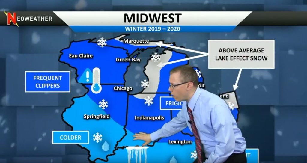
Neoweather expects very active weather across the Midwest this winter. The typical jet stream cold will come down from Canada, but the lakes are expected to stay warmer causing above average lake effect snowfall. The most frigid air is expected to hit in early January when the most lake effect snow is expected to blast northern and western Michigan as well as Cleveland. If the lakes don’t freeze as expected, the lake effect snow becomes a big issue for these areas. Frequent clippers are expected across the region bringing reinforcing cold air behind them along with a wind shift that will favor more lake effect snow.
2019-2020 Midwest Region Long Range Forecast Map
In the lower Ohio Valley and mid Mississippi Valley it will still be cold with some snow, but Neoweather is also predicting rain and ice. From the Nationwide forecast we know that this is where the pressure systems merge. Higher than average temperatures from the Southwest merging into lower than average temperatures in the North will make the Southern Midwest region experience rain and ice.
Looking for more long range forecasts? Check out other weather forecast blog posts from Neoweather brought to you by Snow Plow News!
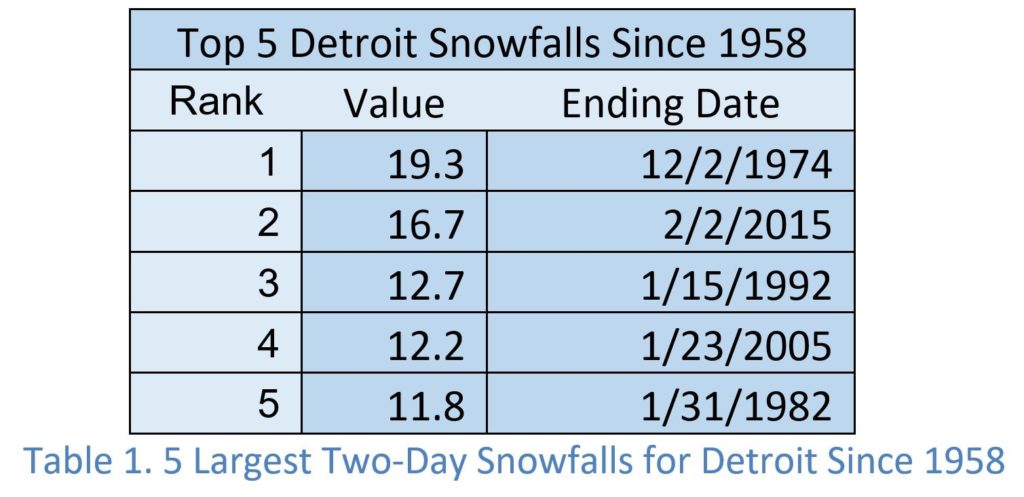
This is the second post in a series that looks at the top five 2-day snowfall events for some of our largest and snowiest cities. This week we look at the top 5 snow storms for Detroit. Specifically, we’re looking at the top 5 snow storms for the Detroit Metropolitan Airport located in Wayne County.
Table 1 lists the top five snowfalls at the airport, over two days, since 1958. This table doesn’t match the top five biggest snowstorms for Detroit. Why? Because we stop the term at two days. Some of the larger snow storms to impact Detroit occurred over 3 days or parts of three days and prior to 1958.
Like Chicago the largest snowstorms in Detroit produce considerable snow but they aren’t very high, compared to other metropolitan areas of the United States. In fact, it is surprising to find that a 12-inch snowfall would rank in the top 5 Detroit snowstorms since 1958. The top five snowstorms produce a range, of 11.8” to 19.3” of snow. You envision Michigan winters and you think snow. Well for Western Michigan and the Upper Peninsula, that is the case. However, Detroit and Southeastern Michigan is not down wind of Lake Michigan and Lake Superior. Detroit is also far enough away from the Atlantic Ocean or Gulf of Mexico that moisture from these sources falls as snow or rain before arriving. These are all significant moisture sources for snow in the Eastern United States. This explains the lighter amounts of snow found in the top 5. The timeframe for our top 5 snow totals is from December 2nd to February 2nd – 3 months. This is a much larger window than Chicago and more typical of cities in the northeast.
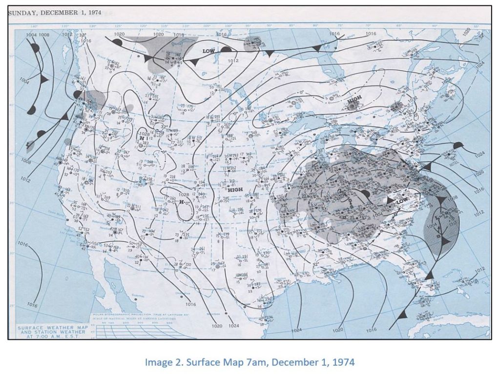
December 2, 1974 Snowstorm
Since Detroit is not downwind or adjacent to any
of the Great Lakes, most moisture that feeds snowstorms originates from the
Atlantic Ocean and, to a lesser degree, the Gulf of Mexico. The surface map in
Image 2 shows an area of low pressure developing in the piedmont of North
Carolina on the morning of Wednesday, December 1, 1974. The central pressure is slightly less than
1004mb. This is not a very low pressure. Light to moderate snow is reported at Detroit
with a temperature of 30˚F. The
surface maps also shows a long fetch from the Atlantic Ocean. Since the storm
has occluded, it is likely the lower and mid-levels of the atmosphere Tennessee
had a similar fetch. This would transfer a deep layer of moisture well inland
towards Detroit and Ohio.
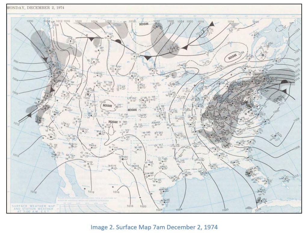
By 7am, Thursday, December 2, 1974 (Image 3), the area of low pressure has moved from the piedmont of North Carolina to southern Pennsylvania and western Maryland. This is very little movement for an area of low pressure over 24 hours. The storm, while moving slowly, also strengthened with the pressure falling to near 992mb. That combination of slow movement and increasing strength resulted in an extended time frame for bringing moisture from the Atlantic Ocean and increased efficiency of snowfall. The temperature at 7am, December 2, 1974 at Detroit was 34℉ with light to moderate snowfall. So, this was a heavy, wet snowfall.
Slow moving storms are common factors in high precipitation
events. For the 1974 Super Snowstorm in Detroit, it was a significant factor.
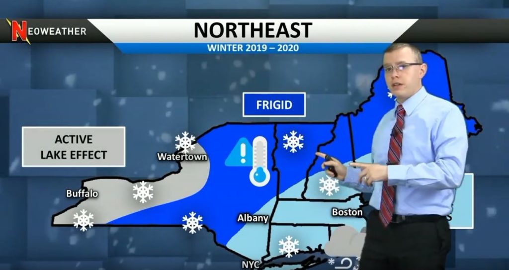
Welcome to this winter’s wonderland – the Northeast! Mark Spencer from Neoweather dug deep into a variety of weather models to determine a long range winter forecast for the Northeast region that looks like the nation’s epicenter of active and snowy weather. He expects a bit of a slow start, but hard and fast turn in January that will lead to loads of lake effect snow in upstate New York, frigid temperatures and frequent coastal storms. Interested in a long range forecast for the entire country or other regions? Check out other Snow Plow News blogs next.
2019/2020 Long Range Winter Forecast: Northeast
Above average snow is expected this winter in the Northeast. Several huge storms are to be expected to hit the area this year from the lakes on in the west and from the systems colliding. We learned in the Nationwide forecast that there will be high pressure systems in the Northeast that get railroaded by low pressure systems from the Southwest and create some intense storms this year. Neoweather expects the Northeast to be the main wintery area this year and “big time in the snow zone” according to Meteorologist and Neoweather President, Brian Ivey.
2019/2020 Long Range Winter Forecast: Northeast
It’s too early to tell how much snow will be hitting the Northeast or when the snow events will come, but all signs are pointing to an active winter for this area. Looking for more long range forecasts? Check out other weather forecast blog posts from Neoweather brought to you by Snow Plow News!
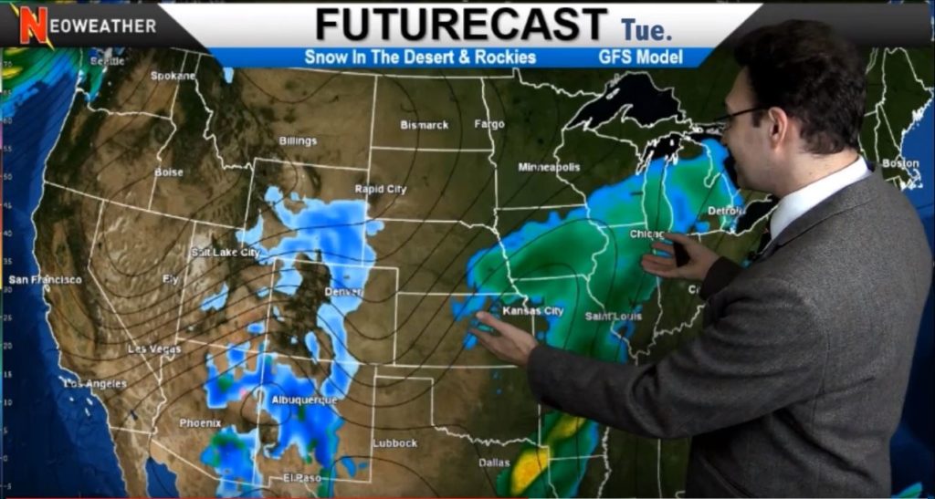
A couple of smaller systems kick off our week starting 11/19/19 with some ice and snow across the Midwest and Great Lakes that moves into New England. Next a larger system in North Dakota and Northern Minnesota brings some snow accumulation. But the real area to watch starts in the Rockies on Wednesday late afternoon and evening. As that system develops it may bring some trouble for Thanksgiving holiday travels for the Midwest and Northeast.
Brian Ivey from Neoweather presents 11/19/19 Forecast
Most of this week stays relatively quiet, with just a few areas of weather to watch. The Rockies will get more snow tomorrow and late this week. While a wet pattern in the Desert Southwest is going to push up across the country along with warm weather pushing up from the Gulf. Happy day for the Northern states! You’ll get a break while the warmest air you’ve seen all month moves into the Midwest and Ohio Valley with some rain as it pushes over Michigan and Upstate New York. No snow is expected until it hits the colder air in New England – so watch that area. There may be some brief lake effect snow on the back end of that system, but nothing huge. Then much of the country sees quiet weather over the weekend before Thanksgiving.
Then it comes… Neoweather is watching a system moving in from the Pacific Northwest that may spice up next week and your Thanksgiving travels. This system moves into the Rockies on Monday bringing widespread snow over most of Nebraska, Colorado and Utah. As it moves east it could be a pretty significant weather system across the Midwest by Wednesday. So keep an eye on that. Different weather models are all suggesting a low pressure event in the middle of the country that could bring a bucket load of wintery weather just in time for Thanksgiving travel when it collides with the warm air that’s moving out in the Midwest and Northeast.
Weather Map for the week of 11/19/19
One thing we know for sure – the winter fun is just starting! November looks like it’s going to end with lots of active weather and that’s just going to reload and repeat for the next several months. This is just an overview. If you want detailed weather information for YOUR area, a private forecasting service like Neoweather can help! Phone apps can give you a general idea of what’s coming, but basing your equipment and staff scheduling decisions upon that generic weather info is risky business. Neoweather prepares you with hourly data that includes all the details you need to manage ice and snow for YOUR specific service area. Contact Neoweather for more details!
You’ve already gotten a taste of winter 2019/2020 but what’s going to happen as it continues? What are the models saying for December, January and February this year? Here’s your official nationwide long range winter forecast from Neoweather. Meteorologist Brian Ivey takes a look at the general overall weather pattern looking at the models with the best historical track record to give you a long range forecast for our country. Check out other Snow Plow News blogs for regional long range forecasts.
2019/2020 Long Range Winter Forecast: Nationwide
The jet stream will bring plenty of cold weather across the middle of the country and then up into the Northeast. However there will be an area of high pressure over the west coast that keeps temperatures potentially well above average. No El Niño or La Niña are expected this year but we do expect a Negative Eastern Pacific Oscillation (EPO). That means there will be an area of warm, moist weather from the Pacific states that may collide with the cold jet stream as it moves east. This could setup a major winter battlefield in the Midwest and Northeast regions. In other words, the temperatures in the western third of the country are expected to be 2-4 degrees above average, especially in the Nevada region where it will be the warmest.
The weather in the Midwest and Northeast will be 2-4 degrees cooler than average, especially around the Great Lakes. When those worlds collide, that’s when the snow events will happen. The Midwest and Ohio Valley will feel those effects with higher than average snowfall this year – but might not be as much as last year. But look out DC, New York and Boston – you may be in a big time snow zone this winter with as much at 150% above average snow fall!
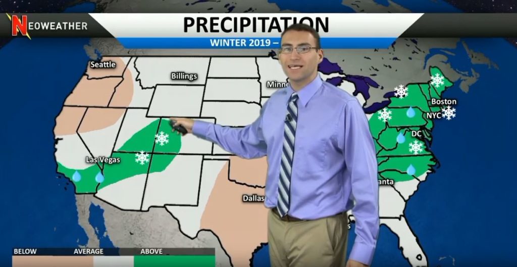
Winter 2019-2020 Precipitation Map
Most of the country is going to be at average precipitation this winter. The exception is the Northeast from Atlanta on up. They will have above average snow fall. The other area to watch is Southern California for above average rain that will turn to snow in higher elevations around the Rockies. Expect drier weather than last year in Seattle and the Northern Pacific states and in the Southern Plains.
Looking for more long range forecasts? Check out other weather forecast blog posts from Neoweather brought to you by Snow Plow News!
Interesting map. I’ve done climate study since the 70s so I stay up to date with a lot & look at a lot of forecasts etc. I think this guy is very close to really correct. I know, mets base winter Dec, Jan, Feb months. I go by the calendar & a cold vs warm season. December 21st is often first day of winter with cold season Oct to April etc. I always figure early Dec is late autumn & March can be very wintry even in South. March was when the South got its biggest snow in the blizzard of 93. I’m familiar with Duluth, MN weather. If you like cold or snow even with a warming earth, you get it every winter there & will for decades to come. If you love heat with humidity, Orlando is your spot. As for the winter forecast in this video, I believe if he makes the cold areas adding just a little more to the West & South, that would be perfection. I’d suspect below average as in entire winter combine as far down as Macon but not FL. As for precip, same thing a little more South just South of Atlanta & then a little more West included but every area he has. I think TN is going to be in the news a lot this winter. That’s a Southern State yet in a location North enough that it can get Northern winter type periods unlike Atlanta. I think there will be Gulf systems moving up this season. That Atlanta Northward area is always on the line it seems. I think just North of Atlanta it’s going to mix up with not only rain but sleet, freezing rain & three big snows. Big for those areas that is. The ice storms will be big news imo & then those systems move up East Coast with big snows imo I also expect a seesaw type winter in all his blue areas. That means times of zonal flows for average then even some above avg days & a return to longer times of below avg days that averages just about how he made forecast. I think he made a great forecast & I’m always picky about it all. I’m not thrilled with Joe Bastardi right now per forecasts but he’s good too. He need to leave politics out of his weather.
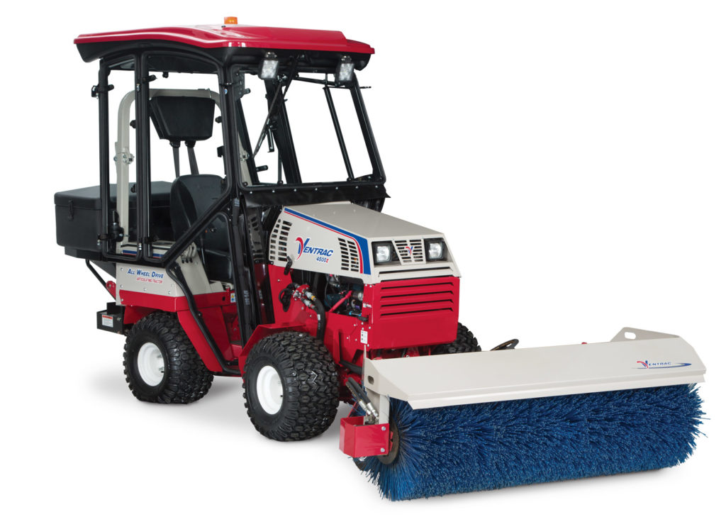
Check out the industry’s leading Ventrac snow tractors for sidewalk snow removal and tight spaces. Both the 4500z and the 3400 Ventrac Compact Tractors have all wheel drive traction to tackle tough terrain along with power steering on an articulating and oscillating frame to maintain a light footprint and impressive agility. Need flexibility? They’ve got it! Choose from over 30 professional grade Ventrac Mount attachments to transform your Ventrac into a productivity powerhouse. These models in our video are shown with the stainless steel drop spreader. It’s the industry leading drop spreader for any type of material!
Ventrac 4500z and 3400 Tractors for Snow Removal
Ventrac 4500z Compact Tractor
The Ventrac 4500Z is powered by a 32.5 HP Kubota engine for ultimate power with the highest peak torque value in Ventrac’s lineup. You can run this machine on gas or propane – it comes Bi-Fuel ready. In addition, you can add an optional propane kit to give this tractor a “green” engine alternative for fuel savings and cleaner burning emissions that can save you money and reduce your carbon footprint. There are loads of accessories you can add to this machine aside from different plow options. For example, get picture-perfect sidewalks with the power broom and drop spreader all from inside a fully enclosed heated cab.
Ventrac 4500z Compact Tractor with Power Broom & Drop Spreader
Ventrac 3400 Zero Turn Tractor
The Ventrac 3400 tractor is the perfect size and design for maneuvering and managing snow on sidewalks, yet powerful enough to move heavy snowfalls too. It features a 34-inch narrow footprint. The 3400 tractor is the industry’s best combination of power, visibility and maneuverability. Choose from over 15 professional grade Ventrac Mount attachments to transform your Ventrac 3400 into a serious snow machine. You can even get a heat controlled cab! Standard on the 3400 is Ventrac’s patented S.D.L.A. control, which allows for easy control of Speed, Direction, Lift and Auxiliary function all with one hand. Combine these features with a tight 28 inch (71 cm) turning radius and you will find the 3400 can tackle jobs reserved for much larger, less maneuverable machines.
Ventrac 3400 is perfect for sidewalk snow removal
“There are multiple different ways to do sidewalks depending upon the size of the company, you’re going to either use a snow blower, shovel, ATV, Ventrac or municipal size machine. So everything has its benefits, one can’t do everything, but we found out that Ventrac can do the most.”
Remember that Pink Snow Equipment raffle we told you about at the Green Industry and Equipment Expo (GIE+EXPO) on October 21-23, 2019 in Louisville, Kentucky? For the seventh year in a row, attendees had a chance to win a limited-edition pink Fisher XV2 V-plow and a SnowEx HELIXX poly hopper spreader. Well, the raffle was a big success and Douglas Dynamics raised a total of $11,173 for breast cancer through Susan G. Komen® Kentucky. In fact, Douglas Dynamics has raised more than $85,000 for the charity since 2013! Well? Who were the winners you ask… Anna Miller from Casa Grande, Arizona won the Fisher XV2 V-plow, and Chad Green from Dyer, Indiana won the SnowEx HELIXX poly hopper spreader! Congratulations to both winners from Snow Plow News!
Pictured in the image (left to right): Keri Foley, Fisher; Lynda Weeks, Executive Director, Susan G. Komen Kentucky; Jeff Kopp, SnowEx; and Jennifer Andrews, Fisher.
“Given the timing of the show coinciding with breast cancer awareness month, and the great support we’ve consistently received … this has always been the ideal event to focus our efforts. We’d like to thank everyone who helped make this another successful fundraising year!”
Katie Sandieson, Douglas Dynamics
Booth space for the promotion at GIE+EXPO was donated by Sellers Expositions; Hedstrom Plastics donated the pink poly hopper for the HELIXX hopper spreader; and Fern Exposition Services donated the booth furnishings.
About Susan G. Komen®
Susan G. Komen® is the world’s leading nonprofit breast cancer organization. The organization works hard towards saving lives and ending breast cancer forever. Komen takes a comprehensive 360-degree approach to fighting this disease across all fronts and supporting millions of people in the U.S. and in countries worldwide. They advocate for patients, drive research breakthroughs, improve access to high-quality care, offer direct patient support and empower people with trustworthy information.
About Fisher Engineering & SnowEx
Fisher Engineering and SnowEx are a part of Douglas Dynamics, North America’s premier manufacturer of vehicle attachments and snow removal equipment. For more than 70 years, they have been innovating products that not only enable people to perform their jobs more efficiently and effectively but also enable snow businesses to increase profitability. To learn more information, visit Fisher Engineering and SnowEx online.
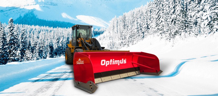
Looking for a big daddy to push snow around even when the ground is not level? Check out Avalanche’s Optimus pusher. It has been around for years and continues to be their top-end snow pusher with a sectional cutting edge, floating blades and self-leveling wear shoes. Each of the two foot blade sections float independently, allowing the whole cutting edge to contour to uneven ground without driver input.
Avalanche Optimus Snow Pusher with Sectional Edge
Floating receivers and self-leveling shoes make the operator’s job easier, and because only the blades float, you can stack snow with an Optimus just like you would with a regular box plow. Each individual trip section adjusts in height in response to the gradient of the ground, ensuring that the blade is in constant contact with the plowing surface. Blade flotation on the high-end Optimus model works on steel compression springs. Far stronger than the poly blocks used on other sectional type plows. The unique Optimus design gives sophisticated blade performance, without compromising the build strength. Braced side panels and a fi xed moldboard maintain structural integrity. The Avalanche Optimus combines strength and sophistication to allow “one-pass” cleaning every time.
Avalanche Optimus Snow Pusher
Why get an Optimus? Steel blades are level, but parking lots are not! Don’t leave snow behind to be forced to make extra passes to do a job well done. Check out the Optimus snow pusher for your next piece of equipment! It comes in blade sizes from 10-24 feet.
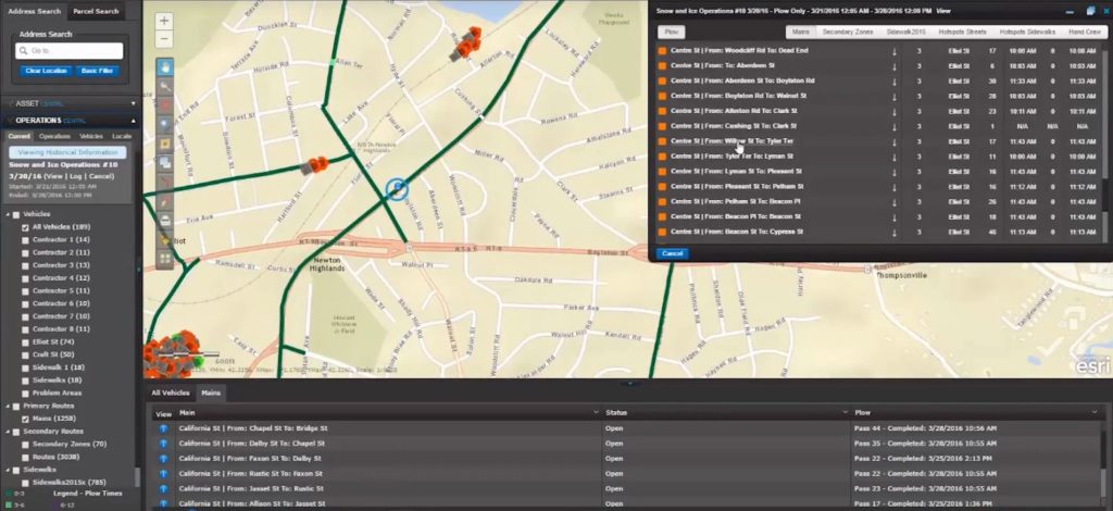
Ready for some serious asset and infrastructure management technology? In other words, are you ready to manage your snow operations all the way from tracking trucks through invoicing? If so, TRAISR may be your solution! With TRAISR you can manage everything related to your snow and ice management business all in one technology solution including GIS, GPS, permits, work orders, snow operations, MS4, vehicle maintenance, inspections, and customer relations.
Traisr for snow operations management
TRAISR stands for “Tracking Real-time Asset Infrastructure System Reporting.” It was originally built for municipalities but the second generation release called “Winter Operations” was created to help snow and ice companies manage their business. It handles tracking snow fleets with GPS devices and a web-based mapping system with a dashboard that gives snow operation managers the ability to quickly monitor where their trucks are and what kind of anti-icing materials are being used in different areas. TRAISR will track trucks, materials and follow their workflow all the way into invoicing and reporting to simplify detailed operations management.
TRAISR Winter Operations Helps with Tracking
The makers of TRAISR are the McMahon group. They pride themselves on providing comprehensive training and support to enable your team to fully harness TRAISR’s array of capabilities. McMahon has been designing, developing and deploying GIS applications like TRAISR for over 15 years. Their application group is well versed in Esri’s and Googles APIs, as well as the latest technologies, which include but are not limited to the following: .net, JavaScript, HTML5, REST/JSON.
TRAISR includes a “GPS Centrl” service that uses GPS and GIS data integration to give you live, real time information to manage emergencies, deal with weather issues, track snow removal vehicles, and report back to residents or customers. This technology will help you make faster, smarter decisions in a current incident, and be better prepared for the next one. Track your vehicles, know where they are and what they are doing.
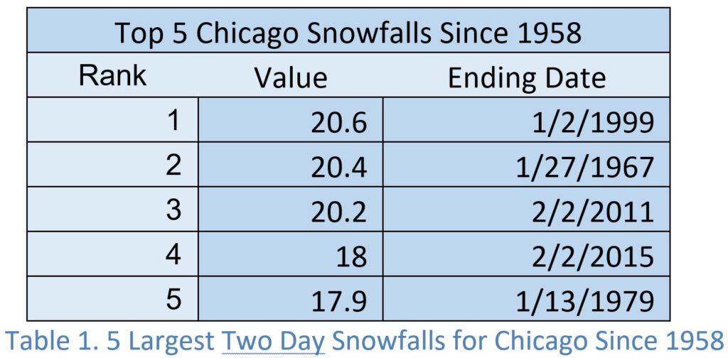
Winter 2019-2020 is off to a pretty strong start. Lots of people are saying we skipped fall and went right into winter. If you are located in the northern half of the country, that definitely feels true, but let’s gain some perspective and take a look at some of the bigger snow storms to hit across the United States in the past. We’re kicking off a series that looks at top five 2-day snowfall for some of our largest and snowiest cities. This week we look at the top 5 snow storms for Chicago.
Table 1 lists the top five snowfalls at O’Hare airport, over two days, since 1958. This table doesn’t match the top five biggest snowstorms for Chicago. Why? Because we stop the term at two days. Some of the larger snow storms to impact Chicago occurred over 3 days or parts of three days.
The largest snowstorms in Chicago produce considerable snow but they aren’t the highest totals, as compared to other metropolitan areas of the United States. However, they still produce significant amounts of snow. The top five snowstorms produced a narrow, but high range, of 17.9” to 20.6” of snow. They also all fall in a narrow time frame of one month – January 2nd to February 2nd. That is very interesting and may be the result of a small sample size or it could be climatology. Compared to other cities in our review, this is a narrow time frame.
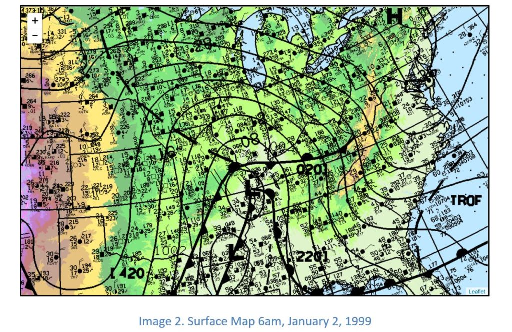
January 2, 1999 Snowstorm
This storm took a track that favors
snow and heavy snow for Chicago. The track is common in our list of top 5
snowstorms for Chicago. Image 2 is a surface map from 6am Saturday, January 2,
1999. It shows an area of low pressure north of Memphis, Tennessee. The central
pressure is less than 1004mb. South of that area of low pressure is another with
a pressure of 1002mb in southern Arkansas. Chicago and the surrounding counties
are reporting temperatures in the teens under moderate to light snow with a
southeast wind. Snow would continue through the day.
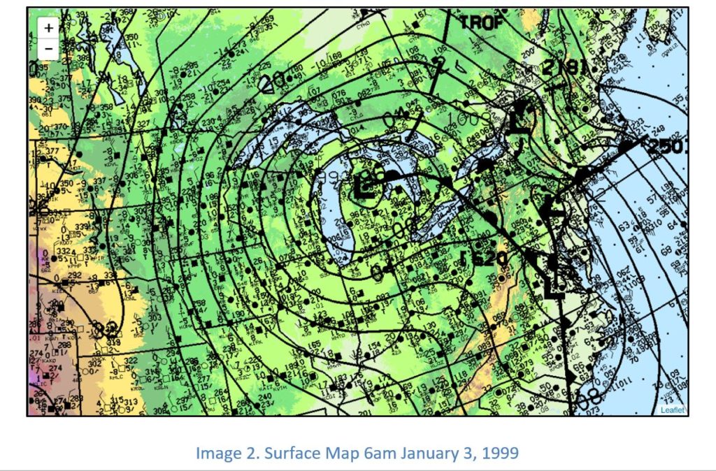
Image 3 is a surface map from 6am
Sunday, January 3, 1999. It shows the area of low pressure has moved north and
east into northern Lower Michigan and strengthened. The pressure has fallen to
993mb. Skies are cloudy to mostly cloudy to cloudy with snow showers in and
around Chicago. Temperatures remain in the teens. By Sunday afternoon, snow
showers began to end and arctic air moved in behind the storm for several days.
This is a prime track for significant snow for Chicago. Here are the reasons why:
The storm travels from the south. This results in a large transport of moisture from the Gulf of Mexico.
The storm track remains east of Chicago. Warm air advection remains to the east and this favors an all snow event for Chicago, as the city remains on the cold side of the storm.
The storm is strengthening as it moves from south to north. Those are three significant and repeatable factors in large Chicago snowstorms.
The National Weather Service out of Romeoville has a very
good write up on the Blizzard of 1967 along with statistics on some of
Chicago’s largest snowstorms. You can read about that here: https://www.weather.gov/lot/67blizzard