Monthly Archives: November 2019

LMN Streamlines Snow Operations from Quotes to Invoicing

LMN is the fastest growing operations software in the landscape and snow & ice industry. They offer mobile apps and snow software for timesheets, job logs with Quickbook sync, salt & service tracking (GPS verified), site map access, route optimization, and estimating. With LMN, your snow and ice company will work with 24/7 real-time information from the field like never before.

See how LMN streamlines snow operations

LMN goes beyond simple software solutions, with integrations and training to drive your snow and ice business forward. Here are some LMN highlights:

  • Mobile Timesheets App – Operators can clock-in and out from any smart device. You’ll get real time tracking of job & payroll hours along with the option to sync to Quickbooks.
  • Live Salt & Service Tracking – Keep track of properties serviced and amount of salt applied. Reports show “live” data so you can bill when ready.
  • GPS Verification – Know where your crews are at all times with site clock-in and out that is GPS verified.
  • Route Optimization – LMN calculates the most efficient route and driving instructions based on the site addresses you enter.
  • Estimating Jobs – Calculate the right price for every job with calculations for labor, equipment, and overhead.
  • Site Maps – instead of putting together site map binders, just upload a digital map to LMN for quick access from any device.
  • Jobsite Watch Add-on – Reduce phone calls and improve customer service by giving customers live, 24/7 access to site service reports from any device.
LMN Business Management Software for Snow Contractors

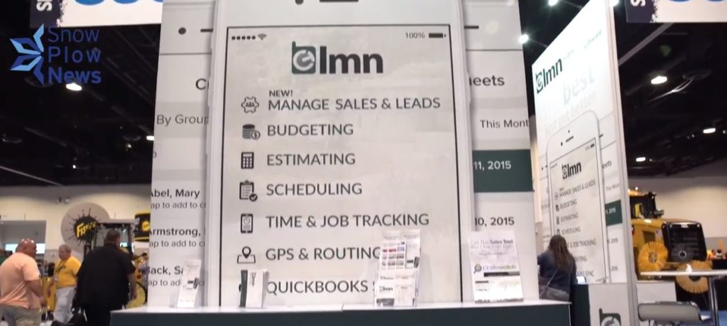
LMN also includes a full CRM for managing customer relations. You can manage everything from the first contact with a client to managing the sales and service tasks while tracking customer communications. LMN’s dashboard report will give you instant information on sales activity and it will even show you where your leads are coming from so you can make better advertising decisions.

Join the growing amount of snow and ice management companies who are putting real-time field information in the palms of their hands, 24/7 with LMN.

Berlon’s Approach to Excellence

John Slawson from Berlon Industries has been in the manufacturing and distribution industries for more than 30 years. With Berlon he realizes they have a strong history and rich culture of product innovation and he’s excited to showcase their new products when they are released. The Snow Grrr and Ice Meltrr are innovative products that lead Berlon’s line up for the snow and ice industry.

About Berlon Industries

John has a strong lean background so he plans to really focus on operational efficiencies at Berlon to improve their lean culture and also continue to really focus on the customer’s needs. He realizes that solving problems and providing highly durable products with low warranty rates are the key.

Berlon Industries is a snow and ice product manufacturer and distributor of highly durable buckets and attachments for skid steers, tractor loaders, compact utility tractors, wheel loaders and tele-handlers used in the snow and ice management industry.

Berlon Industries of Hustisford, Wisconsin

End users of Berlon products appreciate the value and durability of their attachments, while Berlon dealers appreciate their reliable delivery standards and outstanding product support. Berlon sells through dealers, online retailers, and directly to end users in the United States and Canada. Contact Berlon Industries for more information.

Pre and Post Thanksgiving Snows

Here it is – Neoweather’s forecast for the much anticipated winter storm hitting the country both before and after Thanksgiving this week! Looks like Midwest and Ohio Valley snow contractors will have to warm up their plate of turkey after some pretty hefty snow clean up. The big news on top of that is the wind. Expect to see gusts up to 60 miles per hour in some areas. Then there’s a reboot storm for the Northern states on Sunday.

Neoweather’s 2019 Thanksgiving Forecast

According to Brian Ivey of Neoweather, the fun starts with strong winds in front of the snow corridor today. The high winds cover Northwest Texas and the Ohio Valley, while the snow band is expected to stretch from the Rockies to across Southeast Minnesota and Northwest Wisconsin. The snow starts in the Rockies (of course) and will move Northeast from there covering Nebraska, South Dakota, Northwest Kansas, then into Iowa, Minnesota, Wisconsin and the Upper Peninsula of Michigan. It lifts north as it moves east across these areas. The snow will be significant, but not to the level of a huge blizzard in the United States. Most of the snow band areas will see up to 5-10 inches. The Rockies and U.P. will see over 10 inches, so get ready to dig out there! There will be lots of rain and winds in front of that system for Michigan, Ohio and the Eastern states.

Anticipated Snow Accumulation for 11/27/2019

The big time winds are another story in and of themselves. There will be widespread gusts of 40-50 miles per hour across much of the Midwest and Northeast. The lake shores may even see up to 60 mile per hour gusts through the day on Wednesday, into early on Thursday. Don’t be surprised if the Macy’s Thanksgiving Parade floats have to stay low due to the winds in New York City.

Second Snow System this Week

Ready for round two? Another system builds up on Friday in the Rockies just as Black Friday shopping is wrapping up for the day. This time it starts in the Southwestern area of the Rockies but moves north rapidly to pound the Dakotas and Minnesota with blizzard conditions over the weekend and early next week. As it hits the northern air of Canada, the system curves down and weakens a bit while it moves over the Great Lakes and into the Northeast on Sunday and Monday.

Looking for accurate weather information that helps you run your snow business? Neoweather builds custom forecasts just for you with hourly data that includes dew points, snow totals, temperatures and more! Stop relying on generic weather apps that can waste your money by having your team deployed too early or too late. Contact Neoweather for a quote!

Metal Pless Plows are Mega Versatile!

Here’s your chance to learn more about the Metal Pless brand of snow plows if you aren’t familiar with this work horses! These plows come in a zillion sizes with a virtual endless amount of features to help you in every winter weather situation. Need a live floating edge? Got it. How about tilting? Yup. Maybe you want hydraulic wings to turn the plow into a pusher. You bet! Backdragging? Of course! Metal Pless plows have it all whether you need a 5 foot, 10 foot or even a 45 foot blade, they’ve got it. And Metal Pless makes their plows for any type of equipment too.

Check out the Metal Pless brand of snow attachments

Metal Pless designs its plows with a unique shape that allows them to push a greater amount of snow further, using less horse power. Metal Pless plows also have a patented universal subframe that is 40% lighter than similar products from other manufacturers and their plows can be fitted to almost all varieties of trucks and tractors.

The patented Liveboxx pusher from Metal Pless is a popular choice for many snow contractors. It can be installed on a skid steer, backhoe or wheel loader. It has a “LiveEdge” soft drive mechanical steep trip edge with heavy duty 24 inch sections. The steel trip edge goes up and down with the imperfection of roads tightly, reducing up to 50% of your salt usage. The fixed wings of this pusher have self-leveling abrasion shoes with a wear plate.

Metal Pless Liveboxx trip edge
Metal Pless Liveboxx pusher trip edge

Since 1976 Metal Pless has been designing, manufacturing and distributing snow plows and graders. They currently have 22 different models of snow plow and pusher attachments. Different sizes and models fit tractors, wheel loaders, skid steers, backhoes, heavy duty trucks, pickups, sidewalk vehicles and graders. Their products are innovative, versatile, dependable and built with the highest quality in materials and workmanship. Metal Pless is a leader in the snow and ice equipment manufacturing. They are known for exceptional durability, high resale value, low maintenance costs, lightweight products and extraordinary customer service.

Official Southeast Long Range Winter Forecast 2019/20

The long range weather forecast for the Southeast region presents a colorful map. Let’s start with the delightful news: If you are in or are going to Florida, this winter is expected to be warm and dry compared to past winters. Yay Florida! However, the rest of the Southeast region is expected to either have lower than average temperatures or frequent “swings” of both higher AND lower than average temps across the middle of the region. Want details on the national long range forecast or other regions? See other long range forecasts from Neoweather in the Snow Plow News blogs.

2019/2020 Long Range Winter Forecast: Southeast

Let’s go back to Florida and relish in that a moment… The southern half of the state will have lower than average precipitation. So not only will Florida be warm this winter, but it will be dry! Time to book your flight for around January if you live up north!

The rest of the Southeast is a mixed pot of different conditions. The northern Tennessee Valley and Smokey Mountain areas will experience the edge of the frequent Canadian clippers and get some snow. The East coast storm track covers Eastern North Carolina and coastal areas where there will be much higher than average precipitation and some snow, especially inland.

2019-2020 Southeast Region Long Range Forecast Map

Most of Dixie will get the “swings” that cover much of the country where Neoweather expects weather to bounce back and forth from both higher and lower than average temperatures. This includes most of Mississippi, Alabama, Georgia and South Carolina. Expect both warm and cold air, wet and dry weather – just depending on the storm track.

Snow Plow News likes to provide weather resources to help you plan your business and life! Check out other blogs if you’d like more weather forecast blog posts from Neoweather brought to you by Snow Plow News!

Official Plains & Deep South Long Range Winter Forecast 2019/20

What’s going to happen this winter in the Plains and Deep South including Kansas, Missouri, Oklahoma, Texas, Arkansas and Louisiana? Robert Carroll of Neoweather shares his long range winter forecast for this region in the video below. Neoweather’s team determines their forecast using a variety of weather models that have been the most reliable over the years. If you have an interest in other long range forecasts, there are plenty to see in the Snow Plow News blogs with national forecasts as well as other long range forecasts for different regions.

2019/2020 Long Range Winter Forecast: Plains & Deep South

Neoweather is forecasting that most of the Plains and Deep South will experience swings of colder than average and warmer than average temperatures this winter. There will be a frequent swing back and forth between those two conditions in Kansas, most of Missouri, Arkansas and parts of Oklahoma and the Texas Panhandle. They will get rain, ice and even some snow as the weather swings back and forth.

The rest of Texas and New Orleans will have warm and dry conditions for much of this winter. A drought is even likely according to Neoweather.

2019-2020 Plains & Deep South Region Long Range Forecast Map

Neoweather specializes in private weather forecasting specifically for the snow and ice management industry and works closely with Snow Plow News to help our readers. If you’d like more long range forecasts be sure to check out other weather forecast blog posts from Neoweather brought to you by Snow Plow News!

Official Northern Plains Long Range Winter Forecast 2019/20

Curious about the long range forecast for the Northern Plains this winter? The 2019-2020 season is expected to product frequent clippers coming down from Canada and frigid temps in Minnesota. The video from Neoweather below gives you a long range winter forecast for the Northern Plains using a variety of reliable weather models. See other Snow Plow News blogs for nationwide forecasts along with videos for different regions.

2019/2020 Long Range Winter Forecast: Northern Plains

North Dakota, Minnesota, and Iowas will get hit will frequent clippers that come down from Canada this winter. Typically clippers produce snow accumulation, but not storms that bury you. Just enough snow to keep snow contractors busy throughout the season, but not overloaded. The frigid weather prediction is covering the northeastern half of Minnesota and just a corner of Iowa. In other areas Neoweather expects average temperatures this season.

Southwest areas of North Dakota and South Dakota along with all of Nebraska will have pendulum swinging weather back and forth from warmer than average to colder than average. This will produce periods of rain, snow and ice throughout the winter.

2019-2020 Midwest Region Long Range Forecast Map

Looking for more insight and other long range forecasts? Look no further! Snow Plow News has many weather forecast blog posts from Neoweather! Like you, we have a strong interest in accurate weather forecasting and long range planning.

Official Mid-Atlantic Long Range Winter Forecast 2019/20

Plenty of snow and cold is expected this winter in the Mid-Atlantic region. Check out the video below for Neoweather’s long range winter forecast for the Mid-Atlantic. They are expecting higher than average lake effect snow up in Erie, Pennsylvania with frigid temperatures in the middle of the region that will lock in and stick around this winter. The coast is on an active storm track this season that should equate to frequent precipitation with rain near the immediate coast and snow inland. Love long range forecasts? See more by reading Snow Plow News blogs for nationwide and other long range forecasts for different regions.

2019/2020 Long Range Winter Forecast: Mid-Atlantic

Neoweather expects some significant ice events in the Mid-Atlantic again this year, especially across Virginia. This is relatively typical for the region and definitely expected this year as well with all the precipitation coming up the coast where it meets the cold and frigid air.

Mid-Atlantic Long Range Map 2019-20

The lake effect snow is the weather news to watch this year. Northwestern Pennsylvania is expected to receive above average snow fall.

Looking for more long range forecasts? Check out other weather forecast blog posts from Neoweather brought to you by Snow Plow News!

Official Rockies & West Long Range Winter Forecast 2019/20

If you are located in the Rockies or in the West, Neoweather is expecting that you’ll experience warmer temperatures and drier weather than usual this winter. So the 2019-2020 ski season is not looking very good, and that’s not great news for our snow contractor friends in that region either. Want to see more long range forecasts? Check out other Snow Plow News blogs for nationwide and different regional forecasts.

2019/2020 Long Range Winter Forecast: Rockies & West

The Northwestern region of the country from Seattle to San Francisco and into most of Utah will experience slightly warmer than average temperatures. While those areas also stay drier than usual, wet weather is predicted for Southern California including Los Angeles and San Diego. When that warm, moist air collides with the Rockies, we’ll see typical mountain snow. That may even be higher than average snow totals in the mountains so there’s some redemption for the skiers and snow resorts!

2019-2020 Rockies & Western Region Long Range Forecast Map

The rest of the Rockies and West will have lots of swing patterns between warm and cool rain, snow and a few icy situations.

Looking for more long range forecasts? Check out other weather forecast blog posts from Neoweather brought to you by Snow Plow News!

2019-2020 Winter Weather Outlook from NOAA

We look at a lot of winter weather long term forecasts around here to help snow contractors get an idea of what’s to come. Usually we use forecasting services that combine a variety of weather models to come up with their own forecast. This time we’re looking directly at the NOAA Winter Weather Outlook for 2019-2020 issued through the Climate Prediction Center. NOAA (National Oceanic and Atmospheric Administration) is a government agency that focuses on predicting changes in climate, weather, oceans and coasts.

Long Range Temperature Forecast

On October 17, 2019, NOAA issued a winter weather outlook for 2019/ 2020 through the Climate Prediction Center. The long-range forecast calls for most of the United States to experience above average temperatures and normal amounts of precipitation. Figure 1 shows most of the contiguous United States, Alaska and Hawaii in brown to orange shading. This color shading denotes areas where above average temperatures are favored for the three months of December 2019 through February 2020.

Figure 1. NOAA Temperature Forecast December 2019 through February 2020

Long range forecasting is very difficult and is not consistently accurate. However, these forecasts still provide value to sectors of our economy – agriculture, government, etc…. They are also difficult to explain to the general public. Figure 1 is telling us that there are slightly better than average probabilities that the overall temperature will be above average from December through February in most areas. It is not telling us when it will be cold, or that it will never be cold this winter. It is telling us that probabilities for below average temperatures are at equal chances for the Northern Plains and western Great Lakes.

Long Range Precipitation Forecast

Winter precipitation forecasting is even more difficult because of the differential impact of snow and ice versus rain. Figure 2 is the long-range forecast for precipitation from December 2019 through February 2020. The forecast favors normal precipitation for most of the United States. Note the areas of green, these are higher probabilities for above average precipitation from the Mid-Atlantic, Great Lakes, Northern Plains, Alaska and Hawaii. The precipitation forecast is not a snowfall forecast and the areas in green are not a guarantee of above average snowfall. The area in green does predict more precipitation (snow, ice and rain) than the long-term average.  It could be all three (snow, ice and rain) or it could be all rain. As with temperatures, this forecast does not predict individual storms.

Figure 2. NOAA Precipitation Forecast December 2019 through February 2020

Snow Plow News Tracks Forecast Accuracy

Snow Plow News plans to track the temperatures and precipitation this winter. We want to know (and we think you want to know) how the actual weather compares to this forecast and how it compares to long term averages.

Here is what we plan to do this winter. January through March, we will write a brief summary of the temperatures and precipitation of the previous 30 days. For example, in early January we will publish an update on the December temperatures and precipitation to show you what parts of the country are receiving below, above and normal temperatures and precipitation. We think that will be neat. And at the end of winter, we can look back and see how accurate the NOAA long range forecast looks compared to the actual data.

Have questions or just want to send a message to Snow Plow News? Contact us online anytime! We’d love to hear from you!