We look at a lot of winter weather long term forecasts around here to help snow contractors get an idea of what’s to come. Usually we use forecasting services that combine a variety of weather models to come up with their own forecast. This time we’re looking directly at the NOAA Winter Weather Outlook for 2019-2020 issued through the Climate Prediction Center. NOAA (National Oceanic and Atmospheric Administration) is a government agency that focuses on predicting changes in climate, weather, oceans and coasts.
Long Range Temperature Forecast
On October 17, 2019, NOAA issued a winter weather outlook for 2019/ 2020 through the Climate Prediction Center. The long-range forecast calls for most of the United States to experience above average temperatures and normal amounts of precipitation. Figure 1 shows most of the contiguous United States, Alaska and Hawaii in brown to orange shading. This color shading denotes areas where above average temperatures are favored for the three months of December 2019 through February 2020.
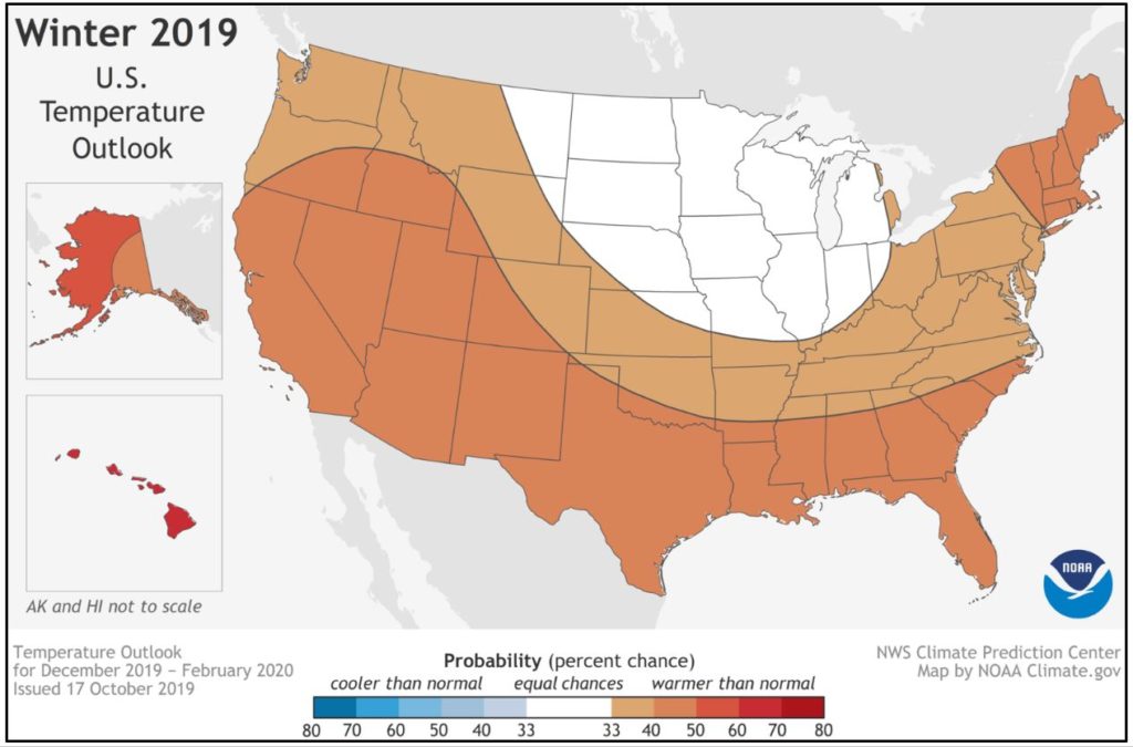
Long range forecasting is very difficult and is not consistently accurate. However, these forecasts still provide value to sectors of our economy – agriculture, government, etc…. They are also difficult to explain to the general public. Figure 1 is telling us that there are slightly better than average probabilities that the overall temperature will be above average from December through February in most areas. It is not telling us when it will be cold, or that it will never be cold this winter. It is telling us that probabilities for below average temperatures are at equal chances for the Northern Plains and western Great Lakes.
Long Range Precipitation Forecast
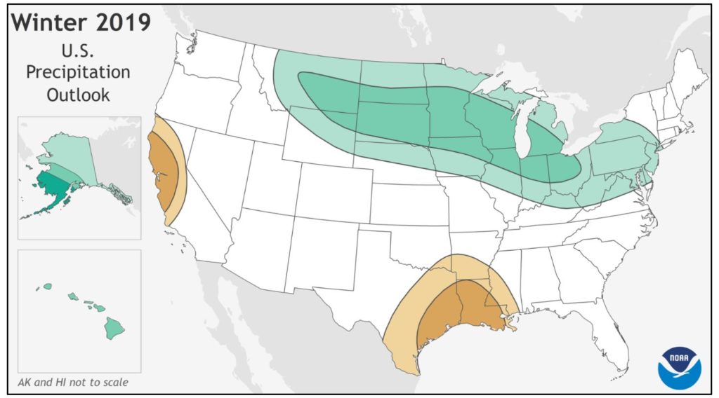
Winter precipitation forecasting is even more difficult because of the differential impact of snow and ice versus rain. Figure 2 is the long-range forecast for precipitation from December 2019 through February 2020. The forecast favors normal precipitation for most of the United States. Note the areas of green, these are higher probabilities for above average precipitation from the Mid-Atlantic, Great Lakes, Northern Plains, Alaska and Hawaii. The precipitation forecast is not a snowfall forecast and the areas in green are not a guarantee of above average snowfall. The area in green does predict more precipitation (snow, ice and rain) than the long-term average. It could be all three (snow, ice and rain) or it could be all rain. As with temperatures, this forecast does not predict individual storms.
Snow Plow News Tracks Forecast Accuracy
Snow Plow News plans to track the temperatures and precipitation this winter. We want to know (and we think you want to know) how the actual weather compares to this forecast and how it compares to long term averages.
Here is what we plan to do this winter. January through March, we will write a brief summary of the temperatures and precipitation of the previous 30 days. For example, in early January we will publish an update on the December temperatures and precipitation to show you what parts of the country are receiving below, above and normal temperatures and precipitation. We think that will be neat. And at the end of winter, we can look back and see how accurate the NOAA long range forecast looks compared to the actual data.
Have questions or just want to send a message to Snow Plow News? Contact us online anytime! We’d love to hear from you!